IMAGES TAKEN NEAR TO
The Sycamores, STOURBRIDGE, DY9 0GG
Introduction
This page details the photographs taken nearby to The Sycamores, DY9 0GG by members of the Geograph project.
The Geograph project started in 2005 with the aim of publishing, organising and preserving representative images for every square kilometre of Great Britain, Ireland and the Isle of Man.

There are currently over 7.5m images from over14,400 individuals and you can help contribute to the project by visiting https://www.geograph.org.uk
Image Map
Images are licensed for reuse under creativecommons.org/licenses/by-sa/2.0
Notes
- Clicking on the map will re-center to the selected point.
- The higher the marker number, the further away the image location is from the centre of the postcode.
Image Listing (13 Images Found)
Images are licensed for reuse under creativecommons.org/licenses/by-sa/2.0
Image
Details
Distance
5
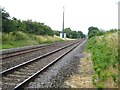
Railway at Level Crossing in Hagley.
Line which has the London Midland Service heading towards Kidderminster.
Image: © Stephen Rogerson
Taken: 26 Jul 2013
0.17 miles
10
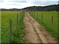
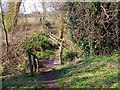
Footpath (across field)
Running from Sweetpool Lane to Brake Mill Farm.
Image: © Stephen Rogerson
Taken: 5 Apr 2016
0.22 miles