IMAGES TAKEN NEAR TO
The Hawthorns, STOURBRIDGE, DY9 0GD
Introduction
This page details the photographs taken nearby to The Hawthorns, DY9 0GD by members of the Geograph project.
The Geograph project started in 2005 with the aim of publishing, organising and preserving representative images for every square kilometre of Great Britain, Ireland and the Isle of Man.

There are currently over 7.5m images from over14,400 individuals and you can help contribute to the project by visiting https://www.geograph.org.uk
Image Map (Loading...)


Getting Data...Please wait
Leaflet Map data © OpenStreetMap
Images are licensed for reuse under creativecommons.org/licenses/by-sa/2.0
Notes
- Clicking on the map will re-center to the selected point.
- The higher the marker number, the further away the image location is from the centre of the postcode.
Image Listing (18 Images Found)
Images are licensed for reuse under creativecommons.org/licenses/by-sa/2.0
Image
Details
Distance
4
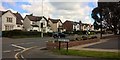
Worcester Road from Newfield Road - Hagley
Image: © Anthony Parkes
Taken: 23 Apr 2016
0.15 miles
5
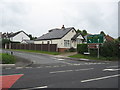
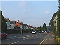
Junction of Newfield Road with the A456 Birmingham to Kidderminster main road
Image: © Richard Rogerson
Taken: 17 May 2009
0.17 miles
6
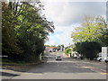
Hagley Approaching A456 and A450 Junction
Image: © Roy Hughes
Taken: 10 Oct 2014
0.19 miles
8
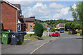
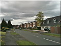
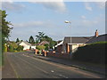
Meadow Croft, Hagley
Meadow Croft is a modernhousing development on the south-western edge of Hagley. The wheely bins on the left make it very clear which house they belong to.
Image: © Stephen McKay
Taken: 21 Jun 2023
0.19 miles
9

Shell Filling Station, Kidderminster Road South
At the junction of Worcester Road (A450) and Kidderminster Road (A456) near West Hagley.
Image: © David Dixon
Taken: 2 Jun 2024
0.20 miles