IMAGES TAKEN NEAR TO
Yieldingtree, STOURBRIDGE, DY9 0EL
Introduction
This page details the photographs taken nearby to Yieldingtree, DY9 0EL by members of the Geograph project.
The Geograph project started in 2005 with the aim of publishing, organising and preserving representative images for every square kilometre of Great Britain, Ireland and the Isle of Man.

There are currently over 7.5m images from over14,400 individuals and you can help contribute to the project by visiting https://www.geograph.org.uk
Image Map
Images are licensed for reuse under creativecommons.org/licenses/by-sa/2.0
Notes
- Clicking on the map will re-center to the selected point.
- The higher the marker number, the further away the image location is from the centre of the postcode.
Image Listing (5 Images Found)
Images are licensed for reuse under creativecommons.org/licenses/by-sa/2.0
Image
Details
Distance
2
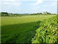
Arable field beside Egg Lane
Arable field beside Egg Lane near Broome.
Image: © Philip Halling
Taken: 27 May 2016
0.19 miles
3
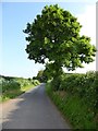
Tree beside Egg Lane
Egg Lane at this point is almost exactly aligned with a Roman road.
Image: © Philip Halling
Taken: 27 May 2016
0.21 miles
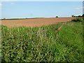
4
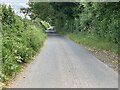
Egg Lane
According to the OS map, this is an old Roman road. It presumably started at Droitwich and headed north west. The OS tracks it to just north east of Halfpenny Green airport, but the present B4176 (nearby) seems straight enough to be "Roman" which would go on to Telford.
Image: © Mike Dodman
Taken: 4 Jul 2024
0.24 miles