IMAGES TAKEN NEAR TO
Hockley Brook Lane, STOURBRIDGE, DY9 0AG
Introduction
This page details the photographs taken nearby to Hockley Brook Lane, DY9 0AG by members of the Geograph project.
The Geograph project started in 2005 with the aim of publishing, organising and preserving representative images for every square kilometre of Great Britain, Ireland and the Isle of Man.

There are currently over 7.5m images from over14,400 individuals and you can help contribute to the project by visiting https://www.geograph.org.uk
Image Map
Images are licensed for reuse under creativecommons.org/licenses/by-sa/2.0
Notes
- Clicking on the map will re-center to the selected point.
- The higher the marker number, the further away the image location is from the centre of the postcode.
Image Listing (7 Images Found)
Images are licensed for reuse under creativecommons.org/licenses/by-sa/2.0
Image
Details
Distance
3
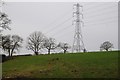
Pylon near Woodlands Farm
An electricity pylon tower over trees near Woodlands Farm.
Image: © Philip Halling
Taken: 11 Jan 2015
0.15 miles
4
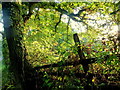
Autumn under the oak
A shaft of sunshine streaming through the foliage in Poolhouse Dingle.
Image: © Jonathan Billinger
Taken: 15 Oct 2013
0.17 miles
5
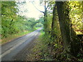
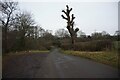
Hockley Brook Lane
At the point where the road passes though Poolhouse Dingle.
Image: © Jonathan Billinger
Taken: 15 Oct 2013
0.19 miles
6
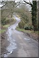
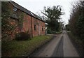
Hookley Brook Lane
Hookley Brook Lane near Dodford.
Image: © Philip Halling
Taken: 11 Jan 2015
0.19 miles