IMAGES TAKEN NEAR TO
Puddle Clay Drive, DY8 4FH
Introduction
This page details the photographs taken nearby to Puddle Clay Drive, DY8 4FH by members of the Geograph project.
The Geograph project started in 2005 with the aim of publishing, organising and preserving representative images for every square kilometre of Great Britain, Ireland and the Isle of Man.

There are currently over 7.5m images from over14,400 individuals and you can help contribute to the project by visiting https://www.geograph.org.uk
Image Map (Loading...)


Getting Data...Please wait
Leaflet Map data © OpenStreetMap
Images are licensed for reuse under creativecommons.org/licenses/by-sa/2.0
Notes
- Clicking on the map will re-center to the selected point.
- The higher the marker number, the further away the image location is from the centre of the postcode.
Image Listing (207 Images Found)
Images are licensed for reuse under creativecommons.org/licenses/by-sa/2.0
Image
Details
Distance
1
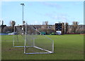
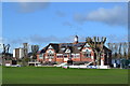
Football and Cricket at the War Memorial Athletic Ground, Amblecote, Stourbridge
For more information about the Cricket Club … see …
Image
For more views of the Cricket Ground … see …
Image
Image
Image
Image
Image
Image
Image: © Terry Robinson
Taken: 13 Feb 2014
0.04 miles
2
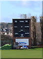
Scoreboard at Stourbridge Cricket Club, War Memorial Athletic Ground, Amblecote, Stourbridge
For more information about the Cricket Club … see …
Image
For more views of the Cricket Ground … see …
Image
Image
Image
Image
Image
Image
Image: © Terry Robinson
Taken: 13 Feb 2014
0.05 miles
3
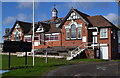
Pavilion at Stourbridge Cricket Club, War Memorial Athletic Ground, Amblecote, Stourbridge
For more information about the Cricket Club … see …
Image
For more views of the Cricket Ground … see …
Image
Image
Image
Image
Image
Image
Image: © Terry Robinson
Taken: 13 Feb 2014
0.05 miles
4
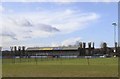
West Stand at Stourbridge Football Club, War Memorial Athletic Ground, Amblecote, Stourbridge
For more information about the Football Club
and a link to the Stourbridge Cricket Club … see …
Image
For more views … see …
Image
Image
Image
Image
Image: © Terry Robinson
Taken: 13 Feb 2014
0.05 miles
5
Stourbridge Cricket Club, War Memorial Athletic Ground, Amblecote, Stourbridge
The Cricket Club was established in 1842 and currently its
first eleven play in the Birmingham District League.
Between 1905 and 1981, the ground was used periodically
as a venue for Worcestershire County Cricket Club
The War Memorial Athletic Ground is also home to
Stourbridge Football Club … aka The Glassboys in
recognition of the Crystal Glass Factories in the vicinity.
For more information and links to views of the Football Club … see …
Image
The Tower Block to the left is located on Frimstone Street
For more views of the Cricket Ground … see …
Image
Image
Image
Image
Image
Image
Image
Image: © Terry Robinson
Taken: 13 Feb 2014
0.06 miles
6
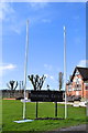
Flag Poles and Sign at Stourbridge Cricket Club, War Memorial Athletic Ground, Amblecote, Stourbridge
For more information about the Cricket Club … see …
Image
For more views of the Cricket Ground … see …
Image
Image
Image
Image
Image
Image
Image: © Terry Robinson
Taken: 13 Feb 2014
0.06 miles
7
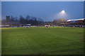
Football match at Stourbridge FC
An Evo-Stik Premier League match at Amblecote.
Image: © Bill Boaden
Taken: 2 Jan 2016
0.08 miles
8
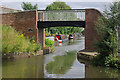
Neville Garratt Bridge, Stourbridge Canal
The last bridge on the Stourbridge Town Arm is this attractive rebuilt footbridge. Neville Garratt was a Black Country businessman, although why this bridge should be named after him is unclear.
Image: © Stephen McKay
Taken: 30 Jul 2008
0.09 miles
9
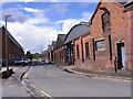
Old Wharf Road
The view near the canal in Stourbridge.
Image: © Gordon Griffiths
Taken: 25 Aug 2012
0.09 miles
10
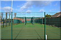
Cricket Nets at Stourbridge Cricket Club, War Memorial Athletic Ground, Amblecote, Stourbridge
For more information about the Cricket Club … see …
Image
For more views of the Cricket Ground … see …
Image
Image
Image
Image
Image
Image
Image: © Terry Robinson
Taken: 13 Feb 2014
0.09 miles