IMAGES TAKEN NEAR TO
Bridgnorth Road, STOURBRIDGE, DY8 3PB
Introduction
This page details the photographs taken nearby to Bridgnorth Road, DY8 3PB by members of the Geograph project.
The Geograph project started in 2005 with the aim of publishing, organising and preserving representative images for every square kilometre of Great Britain, Ireland and the Isle of Man.

There are currently over 7.5m images from over14,400 individuals and you can help contribute to the project by visiting https://www.geograph.org.uk
Image Map
Images are licensed for reuse under creativecommons.org/licenses/by-sa/2.0
Notes
- Clicking on the map will re-center to the selected point.
- The higher the marker number, the further away the image location is from the centre of the postcode.
Image Listing (48 Images Found)
Images are licensed for reuse under creativecommons.org/licenses/by-sa/2.0
Image
Details
Distance
1
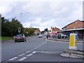
Highpark Avenue Junction
The junction with Bridgnorth Road, Wollaston.
Image: © Gordon Griffiths
Taken: 28 Aug 2010
0.06 miles
2
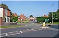
Hamilton Avenue seen from High Park Avenue Wollaston
Ahead is Hamilton Avenue, here seen from High Park Avenue. The road running across the centre is Bridgnorth Road which is the A458. To the left Bridgnorth is 13 miles away and to the right Stourbridge town centre is 1 mile away.
Image: © P L Chadwick
Taken: 27 Sep 2008
0.06 miles
4
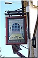
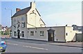
The Gate Hangs Well pub sign, 1 High Park Avenue, Wollaston
Wollaston formerly a village but now, more or less, part of the town of Stourbridge is very well off for public houses. This is the sign of The Gate Hangs Well which states it is an Enterprise Inns Free House.
The name is common in the Midlands, and sometimes found as The Hanging Gate and The Gate Hangs High. It is thought to be connected to a pub's proximity to a church gate, toll gate or town gate, so perhaps there was a toll gate around here in the past. The sign in rural areas is sometimes a miniature five barred gate. In this case, it looks like the portcullis to a castle rather than a conventional gate. On some signs there is also a verse, usually "The gate hangs well, and hinders none. Refresh and pay, and travel on". Originally the none was non and presumably the old pronuciation meant it rhymed with on.
Image
Image: © P L Chadwick
Taken: 27 Sep 2008
0.08 miles
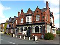
5
The Gate Hangs Well, 1 High Park Avenue, Wollaston
On the corner of the busy A458 (Bridgnorth Road) and High Park Avenue, this pub is one of several in the vicinity. It was certainly in existence as a pub in 1871 but may well be much older.
Image
Image: © P L Chadwick
Taken: 27 Sep 2008
0.08 miles
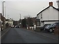
6
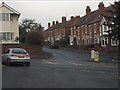
Terraced housing on Bridle Road
Viewed from Gladstone Road.
Image: © Peter Whatley
Taken: 17 Jan 2012
0.08 miles
7
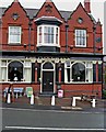
The Plough Inn (2), 154 Bridgnorth Road, Wollaston
The date of 1898 appears above the bay window on the first floor. It can therefore be assumed that the building dates from then, though it may not have been a pub for all of its life. A very many years ago this pub was supplied with beers by a local brewer John & Horace G. Pearson, who were based at the former Cottage Spring pub (currently known as Graham's Place).
Image
Image: © P L Chadwick
Taken: 7 Aug 2010
0.09 miles
8
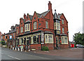
The Plough Inn (1), 154 Bridgnorth Road, Wollaston
A large pub on the Bridgnorth Road. It serves food, and has a pool table and a beer garden.
Image
Image: © P L Chadwick
Taken: 7 Aug 2010
0.09 miles
10
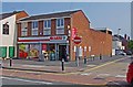
SPAR supermarket, 147 Bridgnorth Road, Wollaston, Stourbridge
Located next to the Unicorn pub and on the corner of Duncombe Street and Bridgnorth Road. This small supermarket/convenience store is one of over 2,500 SPAR branded stores in the UK, although they are not all in the same ownership. Originally founded in the Netherlands in 1932, SPAR stores are to be found in many other countries too but ownership arrangements vary between countries.
Image: © P L Chadwick
Taken: 5 Jul 2013
0.11 miles