IMAGES TAKEN NEAR TO
The Crescent, STOURBRIDGE, DY8 2XB
Introduction
This page details the photographs taken nearby to The Crescent, DY8 2XB by members of the Geograph project.
The Geograph project started in 2005 with the aim of publishing, organising and preserving representative images for every square kilometre of Great Britain, Ireland and the Isle of Man.

There are currently over 7.5m images from over14,400 individuals and you can help contribute to the project by visiting https://www.geograph.org.uk
Image Map (Loading...)


Getting Data...Please wait
Leaflet Map data © OpenStreetMap
Images are licensed for reuse under creativecommons.org/licenses/by-sa/2.0
Notes
- Clicking on the map will re-center to the selected point.
- The higher the marker number, the further away the image location is from the centre of the postcode.
Image Listing (15 Images Found)
Images are licensed for reuse under creativecommons.org/licenses/by-sa/2.0
Image
Details
Distance
9
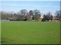
Hagley Park
The park is used for social recreation and also football and cricket.
Image: © Stephen Rogerson
Taken: 25 Mar 2011
0.21 miles
10
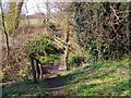
Bridge in Sweetpool Nature Reserve
Image: © Stephen Rogerson
Taken: 7 Apr 2015
0.23 miles