IMAGES TAKEN NEAR TO
Market Street, DY8 1FG
Introduction
This page details the photographs taken nearby to Market Street, DY8 1FG by members of the Geograph project.
The Geograph project started in 2005 with the aim of publishing, organising and preserving representative images for every square kilometre of Great Britain, Ireland and the Isle of Man.

There are currently over 7.5m images from over14,400 individuals and you can help contribute to the project by visiting https://www.geograph.org.uk
Image Map (Loading...)


Getting Data...Please wait
Leaflet Map data © OpenStreetMap
Images are licensed for reuse under creativecommons.org/licenses/by-sa/2.0
Notes
- Clicking on the map will re-center to the selected point.
- The higher the marker number, the further away the image location is from the centre of the postcode.
Image Listing (185 Images Found)
Images are licensed for reuse under creativecommons.org/licenses/by-sa/2.0
Image
Details
Distance
1
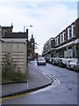
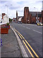
Market Street View
The scene in a town street in Stourbridge.
Image: © Gordon Griffiths
Taken: 28 Aug 2010
0.00 miles
2
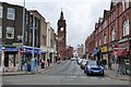
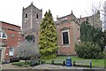
Market Street
View along Market Street in Stourbridge, The tower on the left is part of the former town hall. The building was designed by Thomas Robinson.
Image: © Philip Halling
Taken: 4 Mar 2022
0.01 miles
3
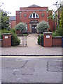
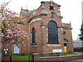
St Thomas's Hall
The 1914 Hall next to the Church in Market Street, Stourbridge.
Image: © Gordon Griffiths
Taken: 28 Aug 2010
0.02 miles
4
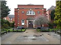
Church Hall
Church Hall next to the Church of St Thomas.
Image: © Philip Halling
Taken: 4 Mar 2022
0.02 miles
5
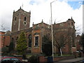
St Thomas?s Church, Stourbridge
Building of the church started in 1728 and was nearly complete by 1736.
http://www.st-thomas-stourbridge.co.uk/history.htm
Image: © Richard Rogerson
Taken: 14 Mar 2010
0.02 miles
6
St Thomas's Church
Georgian Church which dates back to 1736.
Image: © Stephen Rogerson
Taken: 14 Apr 2011
0.03 miles
7
St Thomas' church, Stourbridge
St Thomas' church was built in the 1720s-30s and is Grade I listed, see: https://historicengland.org.uk/listing/the-list/list-entry/1343197?section=official-list-entry
Image: © Philip Halling
Taken: 4 Mar 2022
0.04 miles
8
Ring Road Churches
The view up New Road, Stourbridge of the Methodist Church and the Spire of Our Lady and All Saints Roman Catholic Church.
Image: © Gordon Griffiths
Taken: 28 Aug 2010
0.05 miles
9
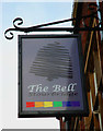
The Bell (2) - sign, 20 Market Street, Stourbridge
Often the name of The Bell reflected the close association that the church had with inns and taverns in the past and particularly in medieval times. Although this former public house dates from 1820 and not the medieval period, it is interesting that it is very near the Church of St. Thomas. In times past it was very common for a pub to be near a church.
Image
Image: © P L Chadwick
Taken: 1 Nov 2014
0.05 miles
10

Stourbridge A451 Worcester Street From Ring Road
Image: © Roy Hughes
Taken: 19 Apr 2014
0.06 miles