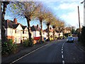
IMAGES TAKEN NEAR TO
Vauxhall Road, STOURBRIDGE, DY8 1EX
Introduction
This page details the photographs taken nearby to Vauxhall Road, DY8 1EX by members of the Geograph project.
The Geograph project started in 2005 with the aim of publishing, organising and preserving representative images for every square kilometre of Great Britain, Ireland and the Isle of Man.

There are currently over 7.5m images from over14,400 individuals and you can help contribute to the project by visiting https://www.geograph.org.uk
Image Map
Images are licensed for reuse under creativecommons.org/licenses/by-sa/2.0
Notes
- Clicking on the map will re-center to the selected point.
- The higher the marker number, the further away the image location is from the centre of the postcode.
Image Listing (136 Images Found)
Images are licensed for reuse under creativecommons.org/licenses/by-sa/2.0
Image
Details
Distance

3
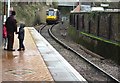
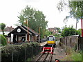
Stourbridge town station
The Stourbridge shuttle is just arriving from Stourbridge junction
Image: © Noisar
Taken: 18 Feb 2020
0.02 miles
4
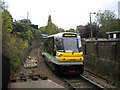
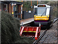
Parry People Mover entering Stourbridge Town
The shuttle from Stourbridge junction, three quarters of a mile up the hill, enters Stourbridge Town station, operated by a Parry People Mover. Invented by a local man, the Parry People Mover uses a flywheel to store energy that is then used to move the vehicle. As it has limited range between charges, it is ideal for this line, particularly as it spends half of its running time travelling downhill. I remember this service being known as the Stourbridge Pullman, a term that now seems more ironic than ever.
Image: © Richard Vince
Taken: 5 Oct 2011
0.03 miles
5
Stourbridge Town station
The station is at the bottom of a steeply-graded branch line (less than a mile long) from Stourbridge Junction on the main Birmingham-Hereford line.
Image: © Stephen Craven
Taken: 7 Feb 2015
0.03 miles
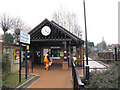
7
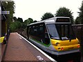
Stourbridge Town Station
At one time there were several locations on Britain's railway network where a shuttle service was provided into a town centre from an inconveniently located 'junction' station on the main line. Stourbridge is the only place where this still happens. The frequent shuttles are provided by a Parry People Mover, designated class 139; it would certainly not be comfortable for a long journey but is ideal for this service. The curious looking vehicle waits to depart from the Town station up the steep bank to Stourbridge Junction.
Image: © Stephen McKay
Taken: 7 Jan 2020
0.03 miles
8
The Stourbridge Shuttle
This single-carriage train shuttles between Stourbridge Town and Stourbridge Junction stations. It is shown here at Stourbridge Town. At Stourbridge Junction, passengers can change for mainline trains. The journey time between the two stations is 3 minutes, and the line is claimed to be Europe's smallest branch line. https://stourbridgeshuttle.com/
Image: © A J Paxton
Taken: 15 Jul 2017
0.03 miles
10
The closed Minnesota Fats snooker hall, Parkfield Road
The date at the top of the building is 1914. The sign still adorning the front says "Minnesota Fats American Fun Bar". It was apparently a snooker hall with bar facilities but there is no fun to be had here now, as the building is firmly boarded up. In 2006 planning permission was given, with conditions, to demolish the building and replace it with a three storey apartment block. Over two years later this has still to happen.
Update: Some time after this picture was taken, the building was demolished, and the construction of new apartments on the site commenced. By the end of June 2010, these appeared to be nearing completion. Image
Image: © P L Chadwick
Taken: 29 Dec 2008
0.03 miles