IMAGES TAKEN NEAR TO
Hinksford Mobile Home Park, KINGSWINFORD, DY6 0BB
Introduction
This page details the photographs taken nearby to Hinksford Mobile Home Park, DY6 0BB by members of the Geograph project.
The Geograph project started in 2005 with the aim of publishing, organising and preserving representative images for every square kilometre of Great Britain, Ireland and the Isle of Man.

There are currently over 7.5m images from over14,400 individuals and you can help contribute to the project by visiting https://www.geograph.org.uk
Image Map
Images are licensed for reuse under creativecommons.org/licenses/by-sa/2.0
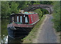
Notes
- Clicking on the map will re-center to the selected point.
- The higher the marker number, the further away the image location is from the centre of the postcode.
Image Listing (145 Images Found)
Images are licensed for reuse under creativecommons.org/licenses/by-sa/2.0
Image
Details
Distance
1
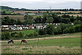
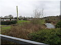
Farmland and mobile homes at Hinksford in Staffordshire
A telephoto assisted image, looking south-east from the footpath by Swindon Rough. Ridgehill Wood is on the skyline centrally, near Kingswinford. The lower line of trees across the scene, at the far end of the pasture, is by the Smestow Brook. Between this and the Staffordshire and Worcestershire Canal is the Hinksford Park mobile homes site.
Wide angle view: Image]
Image: © Roger Kidd
Taken: 24 Aug 2017
0.01 miles
2
Staffordshire farmland near Hinksford
Looking south-east from the footpath by Swindon Rough. Ridgehill Wood is on the skyline centrally, near Kingswinford. The line of trees across the scene at the far end of the pasture is by the Smestow Brook. Between this and the Staffordshire and Worcestershire Canal is the Hinksford Park mobile homes site.
Image: © Roger Kidd
Taken: 24 Aug 2017
0.01 miles
3
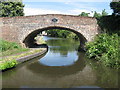
Hinksford Bridge (No 38), Staffs and Worcs Canal
Image: © Richard Rogerson
Taken: 19 Jul 2010
0.02 miles
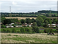
4
Hinksford Park View
The view of the Mobile Home Park near Swindon.
Image: © Gordon Griffiths
Taken: 18 Jan 2021
0.03 miles
5
Hinksford Mobile Home Park
A small part of South Staffordshire Council's Hinksford Mobile Home Park, with a frost covered wood in the distance.
Image: © P L Chadwick
Taken: 22 Dec 2009
0.03 miles
6
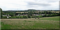
Farmland and mobile homes near Hinksford. Staffordshire
This telephoto assisted image from the footpath by Swindon Rough shows part of the mobile homes site at Hinksford Park. Ridgehill Wood is on the skyline, about 1·4 miles (2·3km) away.
Image: © Roger Kidd
Taken: 24 Aug 2017
0.04 miles
7
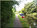
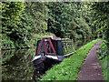
Canal Mooring
The view towards Hinksford Bridge on the Staffordshire and Worcestershire Canal.
Image: © Gordon Griffiths
Taken: 19 Jun 2017
0.04 miles
8
Moored narroboat near Hinksford in Staffordshire
This is the Staffordshire and Worcestershire Canal, looking south-west towards Stourton from near Hinksford Bridge, No 38. The Monarch's Way long distance footpath passes along the towpath here. https://en.wikipedia.org/wiki/Monarch%27s_Way
Image: © Roger Kidd
Taken: 24 Aug 2017
0.04 miles
9

Canal at Hinksford in Staffordshire
This is the Staffordshire and Worcestershire Canal, looking south-west towards Stourton from Hinksford Bridge, No 38.
Image: © Roger Kidd
Taken: 24 Aug 2017
0.04 miles