IMAGES TAKEN NEAR TO
The Waterfront, Level Street, BRIERLEY HILL, DY5 1XE
Introduction
This page details the photographs taken nearby to The Waterfront, Level Street, DY5 1XE by members of the Geograph project.
The Geograph project started in 2005 with the aim of publishing, organising and preserving representative images for every square kilometre of Great Britain, Ireland and the Isle of Man.

There are currently over 7.5m images from over14,400 individuals and you can help contribute to the project by visiting https://www.geograph.org.uk
Image Map
Images are licensed for reuse under creativecommons.org/licenses/by-sa/2.0
Notes
- Clicking on the map will re-center to the selected point.
- The higher the marker number, the further away the image location is from the centre of the postcode.
Image Listing (251 Images Found)
Images are licensed for reuse under creativecommons.org/licenses/by-sa/2.0
Image
Details
Distance
1
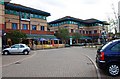
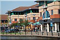
Waterfront East, Brierley Hill
View of some of the bars on this section of The Waterfront complex.
Image: © Brian Clift
Taken: 24 Sep 2009
0.01 miles
3
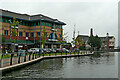
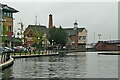
Canal in the Waterfront Business Park near Merry Hill, Dudley
Looking south towards Merry Hill, the Dudley No 1 Canal is passing through the Waterfront Business Park, adjacent to the Merry Hill Shopping Centre. By the footbridge is the Brewers Wharf public house, now refurbished (2017) as The Brierley Hop House.
The business park was built on the site of the demolished Round Oak Steel works, which closed in 1982. Construction was during 1989 and 1990.
Image: © Roger Kidd
Taken: 26 Aug 2010
0.02 miles
4
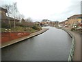
Waterfront Canal
The Waterfront was developed on the hill above the Merry Hill Centre next to the Dudley No 1 Canal.
Image: © Gordon Griffiths
Taken: 1 Jan 2015
0.02 miles
5
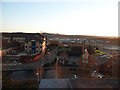
Marina at Merry Hill
View from the Copthorne Hotel in Merry Hill.
Image: © Stephen Sweeney
Taken: 9 Jan 2011
0.02 miles
6
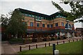
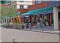
The Waterfront, Brierley Hill
Office workers and shoppers enjoying lunchtime refreshments in the sun.
Image: © Brian Clift
Taken: 9 Sep 2009
0.02 miles
7
Dudley No 1 Canal near Merry Hill, Dudley
Looking south towards Merry Hill, the Dudley No 1 Canal is passing through the Waterfront Business Park, adjacent to the Merry Hill Shopping Centre. By the footbridge is the Brewers Wharf public house.
The business park was built on the site of the demolished Round Oak Steel works, which closed in 1982. Construction was during 1989 and 1990.
Update: CAMRA reports in 2017 that the former Brewers Wharf, a large canalside pub, has recently undergone a profound transformation in both name and nature. Now dubbed the "Brierley Hop House", this is a trendy wet-led establishment with dim lighting and plenty of hideaways to enjoy a drink with friends or to mark a special occasion.
There is a full gin and cocktail menu in addition to the keg and cask products. The food menu largely comprises of burgers and other grills. The first floor can be reserved for meetings or private functions. The car park is Pay and Display but tickets can be redeemed* inside the pub."
* Don't forget to do it when you enter.
Image: © Roger Kidd
Taken: 26 Aug 2010
0.03 miles
8
Waterfront East, Brierley Hill
View of Wetherspoons pub.
Image: © Brian Clift
Taken: 24 Sep 2009
0.03 miles
10
Waterfront East, Brierley Hill
View of Dudley Court.
Image: © Brian Clift
Taken: 24 Sep 2009
0.04 miles