IMAGES TAKEN NEAR TO
Harts Hill Way, BRIERLEY HILL, DY5 1JQ
Introduction
This page details the photographs taken nearby to Harts Hill Way, DY5 1JQ by members of the Geograph project.
The Geograph project started in 2005 with the aim of publishing, organising and preserving representative images for every square kilometre of Great Britain, Ireland and the Isle of Man.

There are currently over 7.5m images from over14,400 individuals and you can help contribute to the project by visiting https://www.geograph.org.uk
Image Map
Images are licensed for reuse under creativecommons.org/licenses/by-sa/2.0
Notes
- Clicking on the map will re-center to the selected point.
- The higher the marker number, the further away the image location is from the centre of the postcode.
Image Listing (113 Images Found)
Images are licensed for reuse under creativecommons.org/licenses/by-sa/2.0
Image
Details
Distance
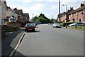
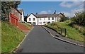
1

Cochrane Road, Woodside
Near the junction with Oakwood Crescent in the direction of Harts Hill.
Image: © Brian Clift
Taken: 9 Sep 2009
0.07 miles
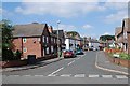
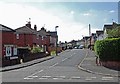
2
Cochrane Road, Woodside
View from the junction with Bradford Road in the direction of Harts Hill.
Image: © Brian Clift
Taken: 9 Sep 2009
0.09 miles
3
Malvern Crescent, Woodside
View from Cochrane Road.
Image: © Brian Clift
Taken: 9 Sep 2009
0.10 miles
4
Cochrane Road, Woodside
View from the junction with Malvern Crescent.
Image: © Brian Clift
Taken: 9 Sep 2009
0.10 miles
5
Oakwood Crescent, Woodside
View from Cochrane Road.
Image: © Brian Clift
Taken: 9 Sep 2009
0.10 miles
6
Cochrane Road, Woodside
This is a spur at the Harts Hill end of Cochrane Road.
Image: © Brian Clift
Taken: 9 Sep 2009
0.10 miles
7
Oakwood Crescent, Woodside
View from Bradford Road.
Image: © Brian Clift
Taken: 9 Sep 2009
0.11 miles
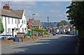
8
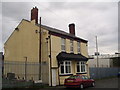
Charter Street, Harts Hill.
I think this building was previously a public house it is possible the name was The Cock and Trumpet.
Image: © Brian Clift
Taken: 15 Jan 2007
0.11 miles
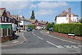
9
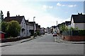
Malvern Crescent, Woodside
View from Bradford Road.
Image: © Brian Clift
Taken: 9 Sep 2009
0.11 miles
10
Industrial buildings west of Pedmore Road
Seen from a narrowboat on the Dudley Canal.
Image: © Christine Johnstone
Taken: 4 Sep 2012
0.12 miles