IMAGES TAKEN NEAR TO
Cornwell Close, TIPTON, DY4 8TU
Introduction
This page details the photographs taken nearby to Cornwell Close, DY4 8TU by members of the Geograph project.
The Geograph project started in 2005 with the aim of publishing, organising and preserving representative images for every square kilometre of Great Britain, Ireland and the Isle of Man.

There are currently over 7.5m images from over14,400 individuals and you can help contribute to the project by visiting https://www.geograph.org.uk
Image Map
Images are licensed for reuse under creativecommons.org/licenses/by-sa/2.0
Notes
- Clicking on the map will re-center to the selected point.
- The higher the marker number, the further away the image location is from the centre of the postcode.
Image Listing (23 Images Found)
Images are licensed for reuse under creativecommons.org/licenses/by-sa/2.0
Image
Details
Distance
2
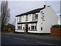
The Old Court House pub, Horseley Heath
A free house, situated on Lower Church Street.
Image: © Richard Law
Taken: 4 Dec 2009
0.15 miles
3
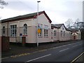
St Martin's C of E primary School, Tipton
The school is attached to St Martin's church, but the church itself is blessed difficult to photograph, being surrounded by walls and high fences.
Image: © Richard Law
Taken: 4 Dec 2009
0.15 miles
4
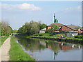
Nearing Dudley Port
To the left of this scene is the main railway line between Birmingham & Wolverhampton. The building on the right is a Mosque & Islamic Cultural Centre.
Image: © Row17
Taken: 6 May 2008
0.16 miles
5
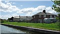
Canalside semis in Wilson Street, Tipton
With houses in blocks of four beyond in Colbourne Road.
Image: © Christine Johnstone
Taken: 10 May 2018
0.18 miles
7
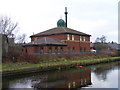
Canal Mosque
A Mosque backs on to the Birmingham Canal near Tipton.
Image: © Gordon Griffiths
Taken: 27 Dec 2008
0.18 miles
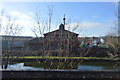
9
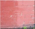
Ordnance Survey Cut Mark
This OS cut mark can be found on the junction of Nos10 & 11 Colbourne Road. It marks a point 138.776m above mean sea level.
Image: © Adrian Dust
Taken: 10 Jul 2021
0.19 miles