IMAGES TAKEN NEAR TO
Park Lane West, TIPTON, DY4 8LE
Introduction
This page details the photographs taken nearby to Park Lane West, DY4 8LE by members of the Geograph project.
The Geograph project started in 2005 with the aim of publishing, organising and preserving representative images for every square kilometre of Great Britain, Ireland and the Isle of Man.

There are currently over 7.5m images from over14,400 individuals and you can help contribute to the project by visiting https://www.geograph.org.uk
Image Map
Images are licensed for reuse under creativecommons.org/licenses/by-sa/2.0
Notes
- Clicking on the map will re-center to the selected point.
- The higher the marker number, the further away the image location is from the centre of the postcode.
Image Listing (105 Images Found)
Images are licensed for reuse under creativecommons.org/licenses/by-sa/2.0
Image
Details
Distance
1
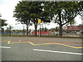
Tipton Green
The view from Park Lane West of the Tipton Junior School.
Image: © Gordon Griffiths
Taken: 16 Jul 2015
0.02 miles
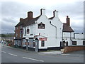
3
The Red Lion
A Pub off Park Lane West, Tipton.
Image: © Gordon Griffiths
Taken: 27 Dec 2008
0.11 miles
4
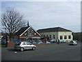
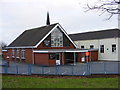
Tipton Green Methodist Church and Church Hall
A well attended Sunday service at the church in Park Lane.
Image: © John M
Taken: 11 Mar 2007
0.11 miles
5
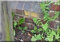
Ordnance Survey Cut Mark
This OS cut mark can be found on the wall at the junction of No2 Sherwood Avenue & No139 Park Lane West. It marks a point 139.550m above mean sea level.
Image: © Adrian Dust
Taken: 10 Jul 2021
0.12 miles
6
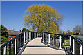
Pitchfork Bridge near Tipton Green in Sandwell
There is housing on both sides of the Birmingham Canal Navigations Old Main Line here south-east of Tipton Junction. Victorian maps pre-dating the housing show a bridge in this position, which must have been used by traffic until this smart replacement footbridge because Baker Street still exists on both sides of the canal! I am surprised that it has not been built "wheel-chair friendly" during its recent refurbisment.
Looking north-east towards the A457 Park Lane West.
Image: © Roger Kidd
Taken: 19 Apr 2021
0.12 miles
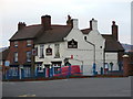
7
Tipton Green Methodist Church
A Church of Park Lane West, Tipton.
Image: © Gordon Griffiths
Taken: 27 Dec 2008
0.12 miles
8
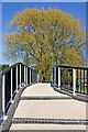
Pitchfork Bridge near Tipton Green in Sandwell
There is housing on both sides of the Birmingham Canal Navigations Old Main Line here south-east of Tipton Junction. Victorian maps pre-dating the housing show a bridge in this position, which must have been used by traffic until this smart replacement footbridge because Baker Street still exists on both sides of the canal! I am surprised that it has not been built "wheel-chair friendly" during its recent refurbisment.
Looking north-east towards the A457 Park Lane West.
Image: © Roger Kidd
Taken: 19 Apr 2021
0.12 miles
9
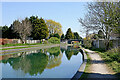
Birmingham Canal Navigations south-east of Tipton Junction, Sandwell
This is the BCN Old Main Line (Wolverhampton Level), looking south-east towards Pitchfork Bridge and Tipton.
Image: © Roger Kidd
Taken: 19 Apr 2021
0.13 miles
10
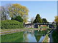
Canal at Pitchfork Bridge near Tipton, Sandwell
This is the BCN Old Main Line (Wolverhampton Level), south-east of Tipton Junction. The footbridge links housing in Baker Street, which is split by the canal.
Image: © Roger Kidd
Taken: 19 Apr 2021
0.13 miles