IMAGES TAKEN NEAR TO
Neptune Street, TIPTON, DY4 8JF
Introduction
This page details the photographs taken nearby to Neptune Street, DY4 8JF by members of the Geograph project.
The Geograph project started in 2005 with the aim of publishing, organising and preserving representative images for every square kilometre of Great Britain, Ireland and the Isle of Man.

There are currently over 7.5m images from over14,400 individuals and you can help contribute to the project by visiting https://www.geograph.org.uk
Image Map
Images are licensed for reuse under creativecommons.org/licenses/by-sa/2.0
Notes
- Clicking on the map will re-center to the selected point.
- The higher the marker number, the further away the image location is from the centre of the postcode.
Image Listing (117 Images Found)
Images are licensed for reuse under creativecommons.org/licenses/by-sa/2.0
Image
Details
Distance
1
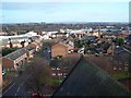
View From The Tower of St Matthew's Church, Tipton
Looking East towards the church of SS Peter & Paul
Image: © Geoff Pick
Taken: 5 Dec 2009
0.03 miles
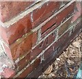
2
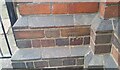
Ordnance Survey Cut Mark
This OS cut mark can be found on the east angle of St Matthews Church on Dudley Road. It marks a point 150.282m above mean sea level.
Image: © Adrian Dust
Taken: 10 Jul 2021
0.05 miles
3
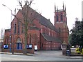
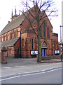
St Matthew C of E Church
Website www.welcome2stmatthews.org.uk
Image: © Stephen Rogerson
Taken: 18 Apr 2013
0.05 miles
4
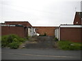
Garages off Bell Street, Tipton
Some derelict, some apparently not.
Image: © Richard Vince
Taken: 29 May 2021
0.07 miles
5
Dudley Road Church
St Matthew's at Tipton.
Image: © Gordon Griffiths
Taken: 27 Dec 2008
0.08 miles
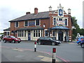
6
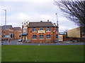
The Pie Factory
Mad O'Rourkes Pub on the Sedgley Road West at Tipton.
Image: © Gordon Griffiths
Taken: 27 Dec 2008
0.11 miles
7
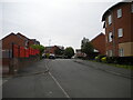
Chapel Street, Tipton
Off High Street.
Image: © Richard Vince
Taken: 29 May 2021
0.11 miles
8
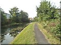
Canal Bend
The view of the Birmingham Canal in Tipton.
Image: © Gordon Griffiths
Taken: 24 Aug 2016
0.11 miles
9
Mad O'Rourke's Pie Factory, Tipton
Down-to-earth boozer with sawdust on the floor, a legendary pie menu and meals served on shovels.
Image: © JThomas
Taken: 22 Aug 2019
0.12 miles
10
Ordnance Survey Cut Mark
This OS cut mark can be found on the wall of No11 Menin Road. It marks a point 152.790m above mean sea level.
Image: © Adrian Dust
Taken: 10 Jul 2021
0.12 miles