IMAGES TAKEN NEAR TO
Morrison Road, TIPTON, DY4 7PU
Introduction
This page details the photographs taken nearby to Morrison Road, DY4 7PU by members of the Geograph project.
The Geograph project started in 2005 with the aim of publishing, organising and preserving representative images for every square kilometre of Great Britain, Ireland and the Isle of Man.

There are currently over 7.5m images from over14,400 individuals and you can help contribute to the project by visiting https://www.geograph.org.uk
Image Map
Images are licensed for reuse under creativecommons.org/licenses/by-sa/2.0
Notes
- Clicking on the map will re-center to the selected point.
- The higher the marker number, the further away the image location is from the centre of the postcode.
Image Listing (60 Images Found)
Images are licensed for reuse under creativecommons.org/licenses/by-sa/2.0
Image
Details
Distance
1
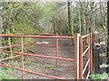
Footpath to Sheepwash Urban Park
Leading to a green space and pools within the built up area in the heart of the Black Country.
Image: © John M
Taken: 11 Mar 2007
0.02 miles
2
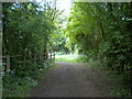
East end of John's Lane, Dudley Port
Taking the form of a gated off disused car park which leads to a footpath to Sheepwash Nature Reserve (through a gate just beyond the derelict buildings on the right).
Image: © Richard Vince
Taken: 29 May 2021
0.03 miles
3
Morrison Road, Dudley Port
Off John's Lane.
Image: © Richard Vince
Taken: 29 May 2021
0.03 miles
4
Track off John's Lane, Dudley Port
A restricted byway, according to the 1:25000 OS map.
Image: © Richard Vince
Taken: 29 May 2021
0.05 miles
5
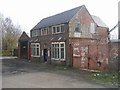
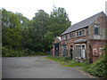
Semi-derelict buildings in John's Lane, Dudley Port
The first impression is that the building is derelict but this is probably misleading. The yard behind the building appears to be used.
Image: © John M
Taken: 11 Mar 2007
0.06 miles
6
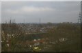
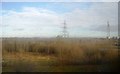
Horseley Heath from the railway
In the background, pylons stride through Sheepwash Urban Park.
Image: © Christopher Hilton
Taken: 9 Feb 2015
0.06 miles
7
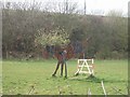
Skewbald showjumper
One of a series of horse sculptures adjacent to the Tame Valley Line between Birmingham and Wolverhampton. Originally all of these were painted black but are self colouring in patches with rust.
Image: © John M
Taken: 11 Mar 2007
0.07 miles
9
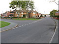
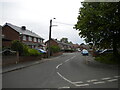
Denbigh and Hudson Roads, Horseley Heath
Denbigh Road is the straight route. Part of a large housing development of broadly similar houses, situated close to Sheepwash Park and Dudley Port.
Image: © Peter Whatley
Taken: 22 Oct 2008
0.09 miles
10
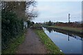
New Main Line Canal towards New Watery Lane Bridge
Image: © Ian S
Taken: 16 Dec 2021
0.10 miles