IMAGES TAKEN NEAR TO
Heath Close, TIPTON, DY4 7PB
Introduction
This page details the photographs taken nearby to Heath Close, DY4 7PB by members of the Geograph project.
The Geograph project started in 2005 with the aim of publishing, organising and preserving representative images for every square kilometre of Great Britain, Ireland and the Isle of Man.

There are currently over 7.5m images from over14,400 individuals and you can help contribute to the project by visiting https://www.geograph.org.uk
Image Map
Images are licensed for reuse under creativecommons.org/licenses/by-sa/2.0
Notes
- Clicking on the map will re-center to the selected point.
- The higher the marker number, the further away the image location is from the centre of the postcode.
Image Listing (39 Images Found)
Images are licensed for reuse under creativecommons.org/licenses/by-sa/2.0
Image
Details
Distance
1
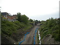
Railway trackbed, Dudley Port (1)
The former South Staffordshire line between Walsall and Dudley, looking towards Walsall from the Lower Church Lane bridge. After more than two decades of proposals, work has finally begun on using the formation for an extension to the Midland Metro light rail system, hence the clearance of vegetation and levelling of the trackbed seen here.
Image: © Richard Vince
Taken: 29 May 2021
0.05 miles
2
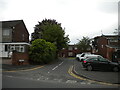
Millwright Close, Dudley Port
A residential cul de sac off Lower Church Lane.
Image: © Richard Vince
Taken: 29 May 2021
0.07 miles
3
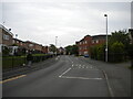
Lower Church Lane, Dudley Port
Looking towards Princes End from the junction with Keelinge Street.
Image: © Richard Vince
Taken: 29 May 2021
0.08 miles
4

Railway trackbed, Dudley Port (2)
The former South Staffordshire line between Walsall and Dudley, looking towards Dudley from the Lower Church Lane bridge. After more than two decades of proposals, work has finally begun on using the formation for an extension to the Midland Metro light rail system, hence the clearance of vegetation and levelling of the trackbed seen here. About a quarter of a mile ahead, the formation passes beneath the Wolverhampton to Birmingham railway line, and the Birmingham Main Line Canal, adjacent to Dudley Port railway station.
Image: © Richard Vince
Taken: 29 May 2021
0.09 miles
5
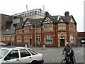
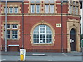
Post Office, Horseley Heath
The terracotta for this Post office building was made by Gibbs and Canning Limited of Tamworth. The building has many super terracotta details.
Image: © Angella Streluk
Taken: 14 Sep 2002
0.09 miles
6

Cul-de-sac off the A461, Horseley Heath
Image: © Peter Whatley
Taken: 22 Oct 2008
0.12 miles


10
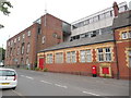
Tipton Telephone Exchange (3)
Taken in Horseley Road near the A461 Horseley Heath, this photo shows the TE with the former Post Office and a red pillar box in front of it. This TE used to have TIPton numbers until the late 1960s, but now has 0121-520, 521, 522, 545 and 557 xxxx numbers, the 0121 referring to the forty eight TEs in the Birmingham area . The postcode of this TE is DY4 7LX.
Image: © David Hillas
Taken: 2 Jun 2018
0.13 miles