IMAGES TAKEN NEAR TO
Galton Close, TIPTON, DY4 7NN
Introduction
This page details the photographs taken nearby to Galton Close, DY4 7NN by members of the Geograph project.
The Geograph project started in 2005 with the aim of publishing, organising and preserving representative images for every square kilometre of Great Britain, Ireland and the Isle of Man.

There are currently over 7.5m images from over14,400 individuals and you can help contribute to the project by visiting https://www.geograph.org.uk
Image Map
Images are licensed for reuse under creativecommons.org/licenses/by-sa/2.0
Notes
- Clicking on the map will re-center to the selected point.
- The higher the marker number, the further away the image location is from the centre of the postcode.
Image Listing (5 Images Found)
Images are licensed for reuse under creativecommons.org/licenses/by-sa/2.0
Image
Details
Distance
1
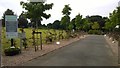
Entrance to Tipton Cemetery
This roadway has been attractively landscaped in recent years to improve the approach to the cemetery off Bridge Road. The photo is taken from the Bridge Road and the Aston Street junction. The small roundabout in the middle distance is approximately the site of an old Smallpox Hospital.
Image: © Paul Collins
Taken: 18 Aug 2016
0.19 miles
2
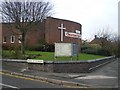
New Road Methodist Church
On the corner of Mount Street (and New Road, oddly)
Image: © Richard Law
Taken: 4 Dec 2009
0.19 miles
3
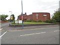
New Road Methodist Church, Tipton
Situated in Mount Street DY4 7DE, this church is one of sixteen such churches in The Black Country Methodist Circuit. Services are held here each Sunday at 10.45am, with activities taking place during the week. Mount Street can be seen to the left of the photo with a school zone road sign, warning of a 20mph speed limit when lights on that sign are flashing.
Image: © David Hillas
Taken: 2 Jun 2018
0.19 miles
4
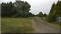
Path on line of former Toll End Canal
This pathway skirts the northern edge of Tipton Cemetery along the line of the Toll End Canal, filled in after it closed in the 1960s. The view is from Bridge Road at the former site of the canal bridge. The gardens of houses to the right of the view were developed decades ago on part of the site of the Cotterill Farm Colliery.
Image: © Paul Collins
Taken: 18 Aug 2016
0.24 miles
5
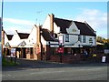
The Kings Arms Tipton
info http://www.marstonspubs.co.uk/thekingsarms/
Image: © Stephen Rogerson
Taken: 7 Nov 2013
0.25 miles