IMAGES TAKEN NEAR TO
Avern Close, TIPTON, DY4 7ND
Introduction
This page details the photographs taken nearby to Avern Close, DY4 7ND by members of the Geograph project.
The Geograph project started in 2005 with the aim of publishing, organising and preserving representative images for every square kilometre of Great Britain, Ireland and the Isle of Man.

There are currently over 7.5m images from over14,400 individuals and you can help contribute to the project by visiting https://www.geograph.org.uk
Image Map
Images are licensed for reuse under creativecommons.org/licenses/by-sa/2.0
Notes
- Clicking on the map will re-center to the selected point.
- The higher the marker number, the further away the image location is from the centre of the postcode.
Image Listing (2 Images Found)
Images are licensed for reuse under creativecommons.org/licenses/by-sa/2.0
Image
Details
Distance
1
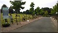
Entrance to Tipton Cemetery
This roadway has been attractively landscaped in recent years to improve the approach to the cemetery off Bridge Road. The photo is taken from the Bridge Road and the Aston Street junction. The small roundabout in the middle distance is approximately the site of an old Smallpox Hospital.
Image: © Paul Collins
Taken: 18 Aug 2016
0.24 miles
2
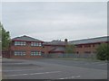
Tipton College
The College stands in Alexandra Road next to Alexandra High School.
Image: © Gordon Griffiths
Taken: 26 May 2007
0.25 miles