IMAGES TAKEN NEAR TO
Marsh Grove, DUDLEY, DY3 4NL
Introduction
This page details the photographs taken nearby to Marsh Grove, DY3 4NL by members of the Geograph project.
The Geograph project started in 2005 with the aim of publishing, organising and preserving representative images for every square kilometre of Great Britain, Ireland and the Isle of Man.

There are currently over 7.5m images from over14,400 individuals and you can help contribute to the project by visiting https://www.geograph.org.uk
Image Map
Images are licensed for reuse under creativecommons.org/licenses/by-sa/2.0
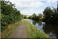
Notes
- Clicking on the map will re-center to the selected point.
- The higher the marker number, the further away the image location is from the centre of the postcode.
Image Listing (106 Images Found)
Images are licensed for reuse under creativecommons.org/licenses/by-sa/2.0
Image
Details
Distance
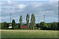
1

Albert Drive View
The view along the Wombourne Road in Swindon, Staffordshire.
Image: © Gordon Griffiths
Taken: 18 Mar 2021
0.02 miles
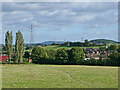
2
Pasture by Swindon in Staffordshire
The housing is in Wombourne Road. The footpath crossing fields has come from Botterham.
Image: © Roger Kidd
Taken: 29 Aug 2010
0.03 miles
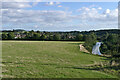
3
Pasture and footpath to Swindon, Staffordshire
Looking south-east, the public footpath crosses pasture between the bridleway near Botterham Bridge and Swindon village. The current path on the ground does wander a bit off the course shown on maps. The housing on the right is in Winston Road.
Image: © Roger Kidd
Taken: 29 Aug 2010
0.08 miles
4
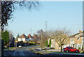
Wombourne Road at Swindon, Staffordshire
Looking north from near the Greyhound public house at the top of High Street.
Image: © Roger D Kidd
Taken: 8 Dec 2010
0.08 miles
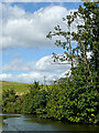
5
Canal and Staffordshire farmland near Swindon
Looking south towards Swindon from the public footpath crossing fields between Botterham and Swindon. The current track on the ground does wander a bit off the course shown on maps. On the right is the Staffordshire and Worcestershire Canal approaching Marsh Lock .
Image: © Roger Kidd
Taken: 29 Aug 2010
0.11 miles
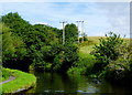
6
Staffordshire & Worcestershire Canal
Towards Botterham Lock.
Image: © Ian S
Taken: 4 Sep 2021
0.11 miles
7
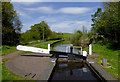
Marsh Lock near Swindon, Staffordshire
Staffordshire and Worcestershire Canal.
Image: © Roger D Kidd
Taken: 8 May 2016
0.11 miles
8
Canal north of Swindon in Staffordshire
This is the Staffordshire and Worcestershire Canal, looking north towards Wombourne.
Image: © Roger Kidd
Taken: 29 Aug 2010
0.12 miles
9
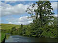
Canal, woodland and pasture near Swindon, Staffordshire
North of Marsh Lock on the Staffordshire and Worcestershire Canal.
Image: © Roger D Kidd
Taken: 25 Aug 2017
0.12 miles
10
Canal north of Swindon in Staffordshire
This is the Staffordshire and Worcestershire Canal, looking north towards Wombourne.
Image: © Roger Kidd
Taken: 29 Aug 2010
0.12 miles