IMAGES TAKEN NEAR TO
Churchfield Street, DUDLEY, DY2 8QR
Introduction
This page details the photographs taken nearby to Churchfield Street, DY2 8QR by members of the Geograph project.
The Geograph project started in 2005 with the aim of publishing, organising and preserving representative images for every square kilometre of Great Britain, Ireland and the Isle of Man.

There are currently over 7.5m images from over14,400 individuals and you can help contribute to the project by visiting https://www.geograph.org.uk
Image Map
Images are licensed for reuse under creativecommons.org/licenses/by-sa/2.0
Notes
- Clicking on the map will re-center to the selected point.
- The higher the marker number, the further away the image location is from the centre of the postcode.
Image Listing (240 Images Found)
Images are licensed for reuse under creativecommons.org/licenses/by-sa/2.0
Image
Details
Distance
1
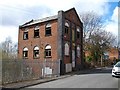
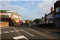
Devonport & Son Clothing Manufacturers
Old disused building which dates back to 1866.
Image: © Stephen Rogerson
Taken: 18 Apr 2013
0.02 miles
2
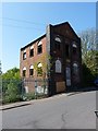
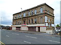
W Devenport & Sons, Clothing Manufacturers
The former premises of the business of that name, built in 1866, but clearly no longer in use, and looking ripe for demolition or redevelopment. This is on Churchfield Street, opposite Brooke Street.
Image: © Richard Law
Taken: 28 Apr 2011
0.02 miles
3
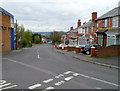
Churchfield Street, Dudley
Looking SE from the junction of King Street and Furnace Road.
Image: © Jaggery
Taken: 5 May 2012
0.02 miles
4
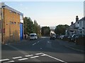
Looking down Churchfield Street, Dudley
A glimpse of the Black Country horizon is a reminder that Dudley is a hill town. The photographer's position at the end of King Street is at about 205m, well below the summit of Dudley Castle Hill.
Image: © Robin Stott
Taken: 29 Sep 2013
0.04 miles
6
Mata Da Mandir, Dudley
Hindu Cultural Association premises on King Street. Mandir (also mandira) appears in Chambers English Dictionary as a word of Hindi origin. Its English meaning is defined as a Hindu or Jain temple.
Image: © Jaggery
Taken: 5 May 2012
0.06 miles
7
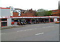
Dudley Motorcycle Centre
Located at 73 King Street, near the High Street and Churchfield Street junctions.
Image: © Jaggery
Taken: 5 May 2012
0.06 miles
8
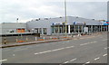
Former Central Italia car dealership, Dudley
The fenced-off former Alfa Romeo and Fiat car dealership premises are on the south side of King Street. A board on the building shows For Sale/To Let.
Image: © Jaggery
Taken: 5 May 2012
0.06 miles
9

Hellier Street, Dudley
View from Vicar Street.
Image: © Brian Clift
Taken: 25 Jul 2010
0.06 miles
10
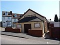
Dudley Gospel Hall, Hellier Street
Located at the junction of Birmingham Street with Castle Hill
Image: © Richard Law
Taken: 28 Apr 2011
0.06 miles