IMAGES TAKEN NEAR TO
Lambert Fold, DUDLEY, DY2 7HF
Introduction
This page details the photographs taken nearby to Lambert Fold, DY2 7HF by members of the Geograph project.
The Geograph project started in 2005 with the aim of publishing, organising and preserving representative images for every square kilometre of Great Britain, Ireland and the Isle of Man.

There are currently over 7.5m images from over14,400 individuals and you can help contribute to the project by visiting https://www.geograph.org.uk
Image Map (Loading...)


Getting Data...Please wait
Leaflet Map data © OpenStreetMap
Images are licensed for reuse under creativecommons.org/licenses/by-sa/2.0
Notes
- Clicking on the map will re-center to the selected point.
- The higher the marker number, the further away the image location is from the centre of the postcode.
Image Listing (40 Images Found)
Images are licensed for reuse under creativecommons.org/licenses/by-sa/2.0
Image
Details
Distance
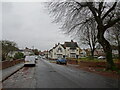
1
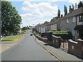
High View Street, Kates Hill
A residential area on a hill east of Dudley town centre.
Image: © David Weston
Taken: 15 Jul 2018
0.08 miles
2
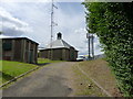
Cawney Hill reservoir house
The Severn Trent Water property attached to the hilltop reservoir at Cawney Hill
Image: © Richard Law
Taken: 17 Aug 2011
0.12 miles
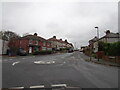
3
Bishop Close
The view in Kate's Hill Dudley.
Image: © Gordon Griffiths
Taken: 20 Aug 2012
0.13 miles
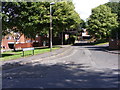
4
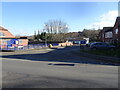
Watson's Green Road Island
The view in Kates Hill, Dudley.
Image: © Gordon Griffiths
Taken: 17 Nov 2022
0.14 miles
5
Watson's Green Road
The view by the Ivy House Pub in Kates Hill, Dudley.
Image: © Gordon Griffiths
Taken: 17 Nov 2022
0.14 miles
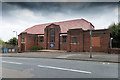
6
Scout Hut Scene
The view in Watson's Green Road in Kates Hill, Dudley. The 7th Dudley Scout Group.
Image: © Gordon Griffiths
Taken: 17 Nov 2022
0.16 miles
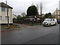
7
St John's Worship Centre
Opposite St. John's church on St. John's Road.
Image: © David P Howard
Taken: 7 Sep 2016
0.16 miles
8
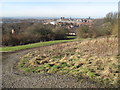
Cawney Hill
Walked up Tansley Hill Road and round boundary of reservoir as best as brambles and other obstacles allowed...good views to the north from near the bench.
Dudley current county/UA top.
Name: Cawney Hill
Hill number: 5499
Height: 251m / 823ft
Area: 39: Central and Eastern England
Class: CoU
Grid ref: SO 95350 89720 (est)
Summit feature: Within reservoir compound
Drop: 27m
Col: 224m SO957895
Image: © Rude Health
Taken: 8 Feb 2011
0.16 miles
9
High View Street
The view in Kate's Hill, Dudley.
Image: © Gordon Griffiths
Taken: 7 Mar 2022
0.16 miles
10
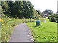
Kate's Hill Path
The view near Dudley Town.
Image: © Gordon Griffiths
Taken: 20 Aug 2012
0.16 miles