IMAGES TAKEN NEAR TO
Buxton Road, DUDLEY, DY2 0SR
Introduction
This page details the photographs taken nearby to Buxton Road, DY2 0SR by members of the Geograph project.
The Geograph project started in 2005 with the aim of publishing, organising and preserving representative images for every square kilometre of Great Britain, Ireland and the Isle of Man.

There are currently over 7.5m images from over14,400 individuals and you can help contribute to the project by visiting https://www.geograph.org.uk
Image Map (Loading...)


Getting Data...Please wait
Leaflet Map data © OpenStreetMap
Images are licensed for reuse under creativecommons.org/licenses/by-sa/2.0
Notes
- Clicking on the map will re-center to the selected point.
- The higher the marker number, the further away the image location is from the centre of the postcode.
Image Listing (77 Images Found)
Images are licensed for reuse under creativecommons.org/licenses/by-sa/2.0
Image
Details
Distance
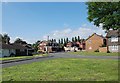
2
Buxton Road, Woodside
View in the direction of Pedmore Road.
Image: © Brian Clift
Taken: 9 Sep 2009
0.03 miles
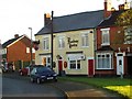
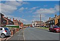
3
Railway Tavern, Woodside
Public house located on Buxton Road near Wood Street.
Image: © Brian Clift
Taken: 9 Sep 2009
0.03 miles
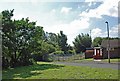
4
The Croft, Woodside
View from Wood Street.
Image: © Brian Clift
Taken: 9 Sep 2009
0.03 miles
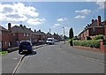
5
Wood Street, Woodside
View from the Railway Tavern in the direction of the Crown public house.
Image: © Brian Clift
Taken: 9 Sep 2009
0.04 miles
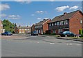
6
Wood Street, Woodside
View in the direction of the Square.
Image: © Brian Clift
Taken: 9 Sep 2009
0.04 miles
7
Wood Street, Woodside
View in the direction of Pedmore Road. The area behind the fence was the location of part of what was The Croft, a tiny street which had its old houses demolished after the second world war. It used to join up with Pedmore Road near the old Woodside and Harts Hill railway station.
Image: © Brian Clift
Taken: 9 Sep 2009
0.05 miles
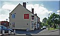
8
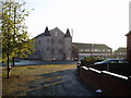
The Square, Woodside.
This area was always known locally as "The Square", it is located at the junction of Holly Hall Road, Wood Street, Crossgate Road, and Holly Hall Road.
The prominent building is the local chapel.
Image: © Brian Clift
Taken: 19 Nov 2006
0.05 miles
9
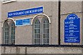
New Testament Church of God, Woodside
A sign on the wall of the church.
Image: © Brian Clift
Taken: 9 Sep 2009
0.05 miles
10
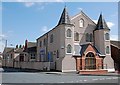
New Testament Church of God, Woodside
View of the church which is located at the Square.
Image: © Brian Clift
Taken: 9 Sep 2009
0.06 miles