IMAGES TAKEN NEAR TO
Cochrane Road, DUDLEY, DY2 0RU
Introduction
This page details the photographs taken nearby to Cochrane Road, DY2 0RU by members of the Geograph project.
The Geograph project started in 2005 with the aim of publishing, organising and preserving representative images for every square kilometre of Great Britain, Ireland and the Isle of Man.

There are currently over 7.5m images from over14,400 individuals and you can help contribute to the project by visiting https://www.geograph.org.uk
Image Map
Images are licensed for reuse under creativecommons.org/licenses/by-sa/2.0
Notes
- Clicking on the map will re-center to the selected point.
- The higher the marker number, the further away the image location is from the centre of the postcode.
Image Listing (73 Images Found)
Images are licensed for reuse under creativecommons.org/licenses/by-sa/2.0
Image
Details
Distance
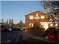
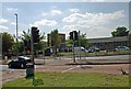
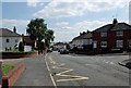
1
Cochrane Road, Woodside
View from the junction with Bradford Road in the direction of Pedmore Road.There used to be a junction with Pedmore Road which was blocked when Pedmore Road was improved.
Image: © Brian Clift
Taken: 9 Sep 2009
0.01 miles
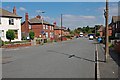
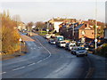
2
Cochrane Road, Woodside
1950s housing on Cochrane Road.
Image: © Richard Law
Taken: 21 Mar 2013
0.02 miles
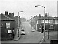
3
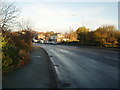
Pedmore Road, Woodside
This is a bridge over the railway and was previously known as "Station Bridge".
Situated where Pedmore Road becomes Highgate Road and is near the junction with the now disused part of Blackbrook Road.
Image: © Brian Clift
Taken: 19 Nov 2006
0.04 miles
4
Woodside Community School
View from Crossgate Street of this school located on Pedmore Road.
Image: © Brian Clift
Taken: 9 Sep 2009
0.04 miles
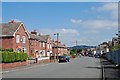
5
Highgate Road, Woodside.
View towards Holly Hall.
Image: © Brian Clift
Taken: 19 Nov 2006
0.05 miles
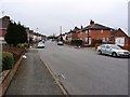
6
Cochrane Road, Woodside
View in the direction of Pedmore Road.
Image: © Brian Clift
Taken: 9 Sep 2009
0.05 miles
7
Bradford Road, Woodside
View of its junction with Cochrane Road.
Image: © Brian Clift
Taken: 9 Sep 2009
0.05 miles
8
Bradford Road, Woodside
View from the junction with Oakwood Crescent in the direction of Cochrane Road.
Image: © Brian Clift
Taken: 9 Sep 2009
0.05 miles
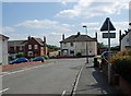
9
Highgate Road, Woodside
1970's view up Highgate Road (it was known then as High Street). Taken from the railway (Station) bridge showing the junction of Highgate Road with Cochrane Road and Wood Street. The Crown public house was demolished later and a new Crown was built on the site. The shop on the left corner was owned by Mr. Dainty.
Image: © Brian Clift
Taken: 1 Jun 1975
0.05 miles