IMAGES TAKEN NEAR TO
Alpine Drive, DUDLEY, DY2 0JH
Introduction
This page details the photographs taken nearby to Alpine Drive, DY2 0JH by members of the Geograph project.
The Geograph project started in 2005 with the aim of publishing, organising and preserving representative images for every square kilometre of Great Britain, Ireland and the Isle of Man.

There are currently over 7.5m images from over14,400 individuals and you can help contribute to the project by visiting https://www.geograph.org.uk
Image Map (Loading...)


Getting Data...Please wait
Leaflet Map data © OpenStreetMap
Images are licensed for reuse under creativecommons.org/licenses/by-sa/2.0
Notes
- Clicking on the map will re-center to the selected point.
- The higher the marker number, the further away the image location is from the centre of the postcode.
Image Listing (125 Images Found)
Images are licensed for reuse under creativecommons.org/licenses/by-sa/2.0
Image
Details
Distance
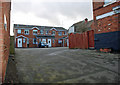
1
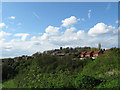
Netherton Hills
View shows, lower left The Marlhole (now a playing field), the houses of Queens Gardens and Alpine Drive centre right, Highbridge Road, centre left, and St Andrews Church.
Image: © Brian Clift
Taken: 1 May 2008
0.03 miles
2
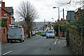
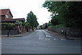
Church Road, Netherton
View from the junction with Alpine Drive.
Image: © Brian Clift
Taken: 22 Jan 2009
0.05 miles
3
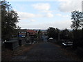
Church Road, Netherton
View of Church Road seen from St Andrews church. Hill Street is to the left and Highbridge Road to the right.
Image: © Steven Roper
Taken: 17 Oct 2009
0.05 miles
4
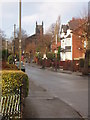
Church Road, Netherton
View towards St Andrews Church. Taken from the junction of Church Road and Hockley Lane.
Image: © Brian Clift
Taken: 1 Jan 2007
0.05 miles
5
Church Road, Netherton
At its junction with Hill Street and Highbridge Road.
Image: © Brian Clift
Taken: 5 Jul 2010
0.06 miles
6
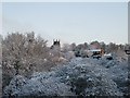
St Andrews Church, Netherton
The church and April snow.
Image: © Brian Clift
Taken: 6 Apr 2008
0.08 miles
7
Bell Road, Netherton
View in the direction of Church Road and Hockley Lane.
Image: © Brian Clift
Taken: 22 Jan 2009
0.09 miles
8
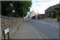
Hill Street, Netherton
View from the junction with Church Road.
Image: © Brian Clift
Taken: 5 Jul 2010
0.09 miles
9
Hope Terrace, Netherton
View from Hampton Street.
Image: © Brian Clift
Taken: 22 Jan 2009
0.09 miles
10
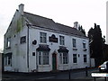
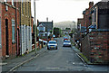
The Pack Horse, Netherton
This ex public house is located on Hill Street at its junction with Hampton Street, Netherton. I have no idea what the current sign refers to.
Image: © Brian Clift
Taken: 31 Dec 2006
0.09 miles