IMAGES TAKEN NEAR TO
St. Edmund Close, DUDLEY, DY1 4EZ
Introduction
This page details the photographs taken nearby to St. Edmund Close, DY1 4EZ by members of the Geograph project.
The Geograph project started in 2005 with the aim of publishing, organising and preserving representative images for every square kilometre of Great Britain, Ireland and the Isle of Man.

There are currently over 7.5m images from over14,400 individuals and you can help contribute to the project by visiting https://www.geograph.org.uk
Image Map
Images are licensed for reuse under creativecommons.org/licenses/by-sa/2.0
Notes
- Clicking on the map will re-center to the selected point.
- The higher the marker number, the further away the image location is from the centre of the postcode.
Image Listing (39 Images Found)
Images are licensed for reuse under creativecommons.org/licenses/by-sa/2.0
Image
Details
Distance
1
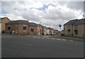
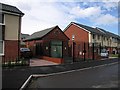
St Edmunds Close
The view of a new housing estate off Priory Road, Dudley.
Image: © Gordon Griffiths
Taken: 23 Jul 2016
0.05 miles
2
New Priory Homes
The start of a new housing estate off Priory Road, Dudley.
Image: © Gordon Griffiths
Taken: 11 Jun 2011
0.05 miles
4
Priory Road at the junction of Mayfield Road
Image: © David Howard
Taken: 3 Jun 2018
0.09 miles
5
Electricity substation, Castle Mill Road, Dudley
Surrounded by newly built houses of the New Priory estate, this old electricity substation looks a little out of place. I'm not sure if it still fulfils its function or has just been left in place as a historic building.
Image: © Rudi Winter
Taken: 8 Jun 2014
0.11 miles
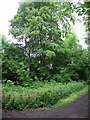
6
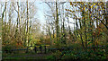
Track junction in Wren's Nest Nature Reserve, Dudley
Looking east, into the Bluebell Park.
Image: © Roger Kidd
Taken: 13 Nov 2022
0.16 miles
7
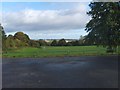
Dudley Playing Field
The view from the car park off Priory Road.
Image: © Gordon Griffiths
Taken: 16 Oct 2012
0.17 miles
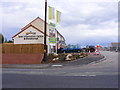
8
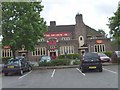
The King Arthur
A pub on the Birmingham New Road.
Image: © Gordon Griffiths
Taken: 7 May 2007
0.17 miles
9
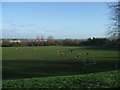
Donkey Pool Playing Fields
A Saturday morning game of football for the kids on the playing fields. Behind them the Black Country skyline extends out into the distance. This would once have been obscured by the smoke from the steelworks and other heavy industry for which the area was noted.
Image: © John M
Taken: 20 Jan 2007
0.17 miles
10
Wren's Nest Nature Reserve
The path follows the outer perimeter of the nature reserve surrounding the Wren's Nest hill with Dudley College on its broad-ridged top.
Image: © Rudi Winter
Taken: 8 Jun 2014
0.17 miles