IMAGES TAKEN NEAR TO
Linwood Road, DUDLEY, DY1 4DX
Introduction
This page details the photographs taken nearby to Linwood Road, DY1 4DX by members of the Geograph project.
The Geograph project started in 2005 with the aim of publishing, organising and preserving representative images for every square kilometre of Great Britain, Ireland and the Isle of Man.

There are currently over 7.5m images from over14,400 individuals and you can help contribute to the project by visiting https://www.geograph.org.uk
Image Map
Images are licensed for reuse under creativecommons.org/licenses/by-sa/2.0
Notes
- Clicking on the map will re-center to the selected point.
- The higher the marker number, the further away the image location is from the centre of the postcode.
Image Listing (97 Images Found)
Images are licensed for reuse under creativecommons.org/licenses/by-sa/2.0
Image
Details
Distance
1

Wrens Nest - NNR
A path through the eastern limb of the anticline, formed from many beds of Silurian period Wenlock limestone. Rich in paleozoic fauna including the rare 'Dudley bug' a trilobite. Famous geologist Sir Roderick Impey Murchison studied the fossils here.
The limestones were uplifted in the Caledonian and the Variscan orogenies (400 and 330ma).
Image: © Ashley Dace
Taken: 24 Mar 2011
0.06 miles
2

Wrens Nest - NNR
A path through the eastern limb of the anticline, formed from many beds of Silurian period Wenlock limestone. Rich in paleozoic fauna including the rare 'Dudley bug' a trilobite. Famous geologist Sir Roderick Impey Murchison studied the fossils here.
The limestones were uplifted in the Caledonian and the Variscan orogenies (400 and 330ma).
Image: © Ashley Dace
Taken: 24 Mar 2011
0.06 miles
3

Entrance to Wren's Nest Nature Reserve in Dudley
Looking south from near Wrens Hill Road.
Image: © Roger Kidd
Taken: 13 Nov 2022
0.06 miles
4
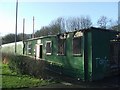
Visitor Centre at Wren's Nest National Nature Reserve
The local vandals have completely burnt out the Warden's Office and Visitor Centre. The Wren's Nest was the first National Geological Nature Reserve when designated in 1956. For photos of the reserve see Image
Image: © John M
Taken: 20 Jan 2007
0.07 miles
5
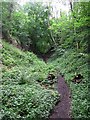
Limestone quarry, Wren's Nest
This ravine is a trench created by quarrying limestone from the Lower Quarried Limestone Member at Wren's Nest. To the left lies the (younger) Nodular Limestone Member, which wasn't quarried as it contains too much sandstone and would therefore have needed additional processing before it could be used in the iron smelting industry. These Silurian limestones were deposited while the area was in a shallow, tropical shelf sea. On the right lies the (older) Coalbrookdale Formation, a mudstone sediment deposited while this area was in deeper water in which shelly creatures couldn't live.
Image: © Rudi Winter
Taken: 8 Jun 2014
0.07 miles
6

Wrens Nest NNR
A path through the eastern limb of the anticline, formed from many beds of Silurian period Wenlock limestone. Rich in paleozoic fauna including the rare 'Dudley bug' a trilobite. Famous geologist Sir Roderick Impey Murchison studied the fossils here.
The limestones were uplifted in the Caledonian and the Variscan orogenies (400 and 330ma).
Image: © Ashley Dace
Taken: 24 Mar 2011
0.07 miles
7
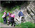
Geology group studying the limestone, Wren's Nest
Wren's Nest is a popular destination for geological societies because of the limestone outcrops in the former quarries surrounding the ridge. Here, the group is studying the fossils in the layer known as the Lower Quarried Limestone Member. To the right, the overlying (younger) Nodular Limestone Member can be seen, characterised by alternating limestone and sandstone deposits. The strata dip by about 60 degrees to the east on this side of the hill. On the western side, they dip in the opposite direction, demonstrating that Wren's Nest is an anticline, i.e. a fold structure with the oldest rock exposures at the centre.
Image: © Rudi Winter
Taken: 8 Jun 2014
0.09 miles
8
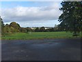
Dudley Playing Field
The view from the car park off Priory Road.
Image: © Gordon Griffiths
Taken: 16 Oct 2012
0.10 miles
9
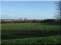
Donkey Pool Playing Fields
A Saturday morning game of football for the kids on the playing fields. Behind them the Black Country skyline extends out into the distance. This would once have been obscured by the smoke from the steelworks and other heavy industry for which the area was noted.
Image: © John M
Taken: 20 Jan 2007
0.12 miles
10
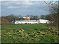
Mons Hill Campus
Another campus of Dudley College located near the summit of Mons Hill.
Image: © John M
Taken: 20 Jan 2007
0.12 miles