IMAGES TAKEN NEAR TO
Rock Cross, Rock, KIDDERMINSTER, DY14 9RN
Introduction
This page details the photographs taken nearby to DY14 9RN by members of the Geograph project.
The Geograph project started in 2005 with the aim of publishing, organising and preserving representative images for every square kilometre of Great Britain, Ireland and the Isle of Man.

There are currently over 7.5m images from over14,400 individuals and you can help contribute to the project by visiting https://www.geograph.org.uk
Image Map
Images are licensed for reuse under creativecommons.org/licenses/by-sa/2.0
Notes
- Clicking on the map will re-center to the selected point.
- The higher the marker number, the further away the image location is from the centre of the postcode.
Image Listing (7 Images Found)
Images are licensed for reuse under creativecommons.org/licenses/by-sa/2.0
Image
Details
Distance
1
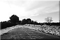
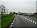
Old alignment, A456
At the junction with Rectory Lane. The A456 was improved in the 1970s with a few bends smoothed out.
Image: © Richard Webb
Taken: 27 Dec 2017
0.06 miles
2
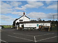
The Collier's Arms
A roadside pub which has a "farm shop" attached, though most of the items on offer were not local produce. Beer (Hobson's) cheap for the area, but food significantly more expensive than nearby Bewdley. Service poor when we visited.
Image: © Peter Whatley
Taken: 20 Mar 2012
0.09 miles
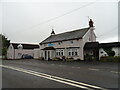
4
The Collier's Arms near Rock
A public house and farm shop located along the A456.
Image: © Mat Fascione
Taken: 16 May 2012
0.12 miles
6
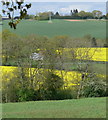
Farmland north of Rock
The wind turbine is near Gorst Hill Farm.
Image: © Mat Fascione
Taken: 16 May 2012
0.15 miles
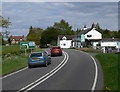
7
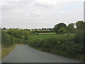
Rolling countryside from Rectory Lane
Image: © Peter Whatley
Taken: 31 Aug 2011
0.20 miles