IMAGES TAKEN NEAR TO
Tenbury Road, KIDDERMINSTER, DY14 9HF
Introduction
This page details the photographs taken nearby to Tenbury Road, DY14 9HF by members of the Geograph project.
The Geograph project started in 2005 with the aim of publishing, organising and preserving representative images for every square kilometre of Great Britain, Ireland and the Isle of Man.

There are currently over 7.5m images from over14,400 individuals and you can help contribute to the project by visiting https://www.geograph.org.uk
Image Map
Images are licensed for reuse under creativecommons.org/licenses/by-sa/2.0
Notes
- Clicking on the map will re-center to the selected point.
- The higher the marker number, the further away the image location is from the centre of the postcode.
Image Listing (20 Images Found)
Images are licensed for reuse under creativecommons.org/licenses/by-sa/2.0
Image
Details
Distance
1
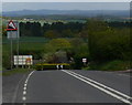
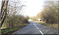
The A456 at Clows Top
Heading towards Bewdley and Kidderminster. The high ground on the horizon is the Clent Hills, 23 kilometres distant.
Image: © Mat Fascione
Taken: 16 May 2012
0.02 miles
2
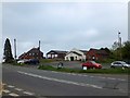
A mixture of buildings at Clows Top
There is a mix of residential, light industry and the public building (village hall) with a large car park at the cross roads in the village.
Image: © David Smith
Taken: 20 May 2013
0.12 miles
5
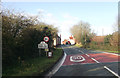
Crossroads warning for Clows Top
From B4202 northbound
Image: © John Firth
Taken: 27 Dec 2012
0.15 miles
6
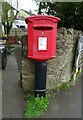
Elizabeth II postbox, Clows Top
Outside the Post Office.
Postbox No. DY14 136.
See Image] for context.
Image: © JThomas
Taken: 17 Apr 2023
0.16 miles
8
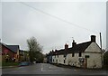
Clows Top village centre
The cross roads forms the old hub of the upland village and the Post Office is still the crux of that.
Image: © Jeremy Bolwell
Taken: 28 Nov 2012
0.16 miles
9
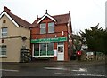
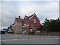
Clows Top Village Stores & Post Office
Showing position of Postbox No. DY14 136.
See Image] for postbox.
Image: © JThomas
Taken: 17 Apr 2023
0.16 miles
10
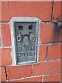
Ordnance Survey Flush Bracket (S6054)
This OS Flush Bracket can be found on the Old Post Office building. It marks a point 221.816m above mean sea level.
Image: © Adrian Dust
Taken: 26 Nov 2015
0.16 miles