IMAGES TAKEN NEAR TO
Neen Sollars, KIDDERMINSTER, DY14 9AH
Introduction
This page details the photographs taken nearby to DY14 9AH by members of the Geograph project.
The Geograph project started in 2005 with the aim of publishing, organising and preserving representative images for every square kilometre of Great Britain, Ireland and the Isle of Man.

There are currently over 7.5m images from over14,400 individuals and you can help contribute to the project by visiting https://www.geograph.org.uk
Image Map
Images are licensed for reuse under creativecommons.org/licenses/by-sa/2.0
Notes
- Clicking on the map will re-center to the selected point.
- The higher the marker number, the further away the image location is from the centre of the postcode.
Image Listing (3 Images Found)
Images are licensed for reuse under creativecommons.org/licenses/by-sa/2.0
Image
Details
Distance
1
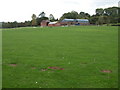
Farm building at Tetshill
In front of the buildings is a cricket pitch.
Image: © Philip Halling
Taken: 8 Oct 2006
0.04 miles
2
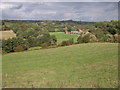
The Rea valley at Tetshill
A railway line used to pass through this valley, now long disused. In front of the farm in the middle distance is a cricket pitch. Further back the church tower of Neen Sollars and Neen Sollars House can be seen.
Image: © Philip Halling
Taken: 8 Oct 2006
0.06 miles
3
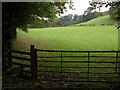
Farmland to the south of Neen Sollars
The course of the old railway line is behind the hedge on the left.
Image: © Philip Halling
Taken: 8 Oct 2006
0.20 miles