IMAGES TAKEN NEAR TO
Station Road, KIDDERMINSTER, DY14 8TT
Introduction
This page details the photographs taken nearby to Station Road, DY14 8TT by members of the Geograph project.
The Geograph project started in 2005 with the aim of publishing, organising and preserving representative images for every square kilometre of Great Britain, Ireland and the Isle of Man.

There are currently over 7.5m images from over14,400 individuals and you can help contribute to the project by visiting https://www.geograph.org.uk
Image Map
Images are licensed for reuse under creativecommons.org/licenses/by-sa/2.0
Notes
- Clicking on the map will re-center to the selected point.
- The higher the marker number, the further away the image location is from the centre of the postcode.
Image Listing (77 Images Found)
Images are licensed for reuse under creativecommons.org/licenses/by-sa/2.0
Image
Details
Distance
1
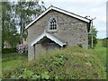
Old Methodist chapel at Stottesdon
Plaque above the door dates this one to 1846 I think - the heyday of the movement - and I can imagine this being filled for Sunday services and serious-minded methodists stalking in to worship, pray and socialise. It doesn't seem yet to have been converted into a home!
https://en.wikipedia.org/wiki/Methodism here to Wikipedia article on Methodism.
Image: © Jeremy Bolwell
Taken: 12 May 2022
0.07 miles
2
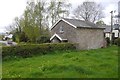
Chapel, Stottesdon
A parish history mentions that Methodism was introduced from the Black Country in the 1820s.
Image: © Richard Webb
Taken: 14 Apr 2017
0.08 miles
3
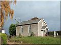
Methodist Chapel, Stottesdon, Shropshire
This quaint little chapel, built around 1858 (?), is precisely on the grid line (according to the OS 1:25000 maps)
Image: © Roger D Kidd
Taken: 6 Nov 2007
0.09 miles
4
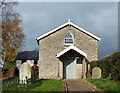
Methodist Chapel, Stottesdon, Shropshire
Built in about 1858, this little limestone chapel is exactly on the 6700 grid line, according to 1:25000 maps, and so was I!
Image: © Roger D Kidd
Taken: 6 Nov 2007
0.09 miles
6
Footpath line at Stottesdon
I am seeking the path and can see the stile and waymarker disc ahead, beside an old chapel. Always good to see an old chapel that is not yet a home!
Image: © Jeremy Bolwell
Taken: 12 May 2022
0.09 miles
7
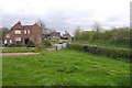
Stottesdon
View from the west, near the chapel.
Image: © Richard Webb
Taken: 14 Apr 2017
0.09 miles
8
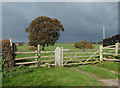
Stile, Gate and Fields. Stottesdon, Shropshire
There are three public footpaths leading northwards of the village. This one starts by the Methodist chapel, and leads across the fields to nowhere in particular, but it is a lovely rural walk! Despite the ominous sky in this picture, it did not rain.
Image: © Roger D Kidd
Taken: 6 Nov 2007
0.10 miles
9
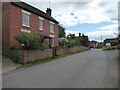
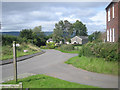
Scene on the main street in Stottesdon
There are a lot of elegant properties in this village, of which this is just one, with an elegant wisteria and nice garden.
Image: © Jeremy Bolwell
Taken: 12 May 2022
0.14 miles
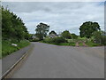
10
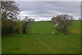
Farmland, Stottesdon
Fields to the north of the village.
Image: © Richard Webb
Taken: 14 Apr 2017
0.14 miles