IMAGES TAKEN NEAR TO
Cleobury Mortimer, KIDDERMINSTER, DY14 8ER
Introduction
This page details the photographs taken nearby to DY14 8ER by members of the Geograph project.
The Geograph project started in 2005 with the aim of publishing, organising and preserving representative images for every square kilometre of Great Britain, Ireland and the Isle of Man.

There are currently over 7.5m images from over14,400 individuals and you can help contribute to the project by visiting https://www.geograph.org.uk
Image Map
Images are licensed for reuse under creativecommons.org/licenses/by-sa/2.0
Notes
- Clicking on the map will re-center to the selected point.
- The higher the marker number, the further away the image location is from the centre of the postcode.
Image Listing (54 Images Found)
Images are licensed for reuse under creativecommons.org/licenses/by-sa/2.0
Image
Details
Distance

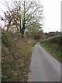
3
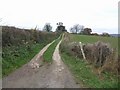
Simon Evans Way
Circular route based upon the daily postal route taken by Simon Evans the Postman/Writer. The route is an 18 mile figure of eight passing the farms in the valley of the Rea Brook between Cleobury Mortimer and Stottesdon.
http://www.cmfa.co.uk/simonevansway.html
Image: © John M
Taken: 3 Nov 2007
0.16 miles
4
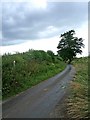
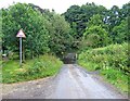
Minor country road
After crossing the ford on the River Rea, this road begins to ascend. It serves various scattered farms, but no places of any significant size. Image
Image: © P L Chadwick
Taken: 5 Jul 2009
0.16 miles
5
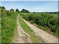
Track and Shropshire Way
The Shropshire Way follows a bridleway on this farm track near Neen Savage.
Image: © Philip Halling
Taken: 14 Jun 2017
0.16 miles
6
Simon Evans Way
Image: © John M
Taken: 3 Nov 2007
0.17 miles
7
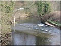
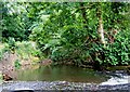
Approaching the ford
To get to the hamlet of Neen Savage (not to be confused with Neen Sollars), this very minor country road has to go through the River Rea by means of a ford. The ford can be seen straight ahead. On the left of the picture, can be seen a footpath leading to a footbridge. This ensures that pedestrians are in no danger of getting their feet wet.
Image: © P L Chadwick
Taken: 5 Jul 2009
0.19 miles
8
Ford, Neen Savage
The road is just visible beneath the Rea.
Image: © Richard Webb
Taken: 2 Apr 2007
0.20 miles
10
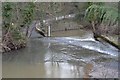
View crossing the ford on the River Rea
This is the view of the River Rea the driver gets, as they cross towards Neen Savage. I stopped the car very briefly to take the photograph. The top of the driver's wing mirror can be seen in the bottom left hand corner!
Image: © P L Chadwick
Taken: 5 Jul 2009
0.20 miles