IMAGES TAKEN NEAR TO
Sytchampton, STOURPORT-ON-SEVERN, DY13 9SX
Introduction
This page details the photographs taken nearby to DY13 9SX by members of the Geograph project.
The Geograph project started in 2005 with the aim of publishing, organising and preserving representative images for every square kilometre of Great Britain, Ireland and the Isle of Man.

There are currently over 7.5m images from over14,400 individuals and you can help contribute to the project by visiting https://www.geograph.org.uk
Image Map
Images are licensed for reuse under creativecommons.org/licenses/by-sa/2.0
Notes
- Clicking on the map will re-center to the selected point.
- The higher the marker number, the further away the image location is from the centre of the postcode.
Image Listing (24 Images Found)
Images are licensed for reuse under creativecommons.org/licenses/by-sa/2.0
Image
Details
Distance
1
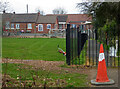
Sytchampton Endowed Primary School
Seen from Cow Lane leading to the community centre and a public footpath.
Image: © Chris Allen
Taken: 3 Mar 2021
0.03 miles
2
Sytchampton Endowed Primary School
Beside the A449 at Sytchampton
Image: © Chris Allen
Taken: 3 Mar 2021
0.03 miles
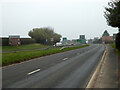
3
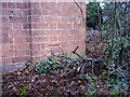
Nineteenth century benchmark on Sytchampton School
This bench mark was established in 1849 during the First primary levelling of England & Wales, and was levelled with a height of 153.0970 feet [46.6640 metres] above mean sea level (Liverpool datum). It was included on the Worcester to Aberystwyth levelling line. The surveyor's description was "No. 19. Mark on front of Lloyd's Charity School ; 2.10 ft. above surface" (Public Abstract p.550). The mark is easily found at the south end of the main building, facing the road.
Image: © Shantavira
Taken: 5 Jan 2016
0.03 miles
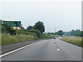
4
A449 at Dark Lane Turning For Sytchampton
Image: © Roy Hughes
Taken: 12 Feb 2018
0.06 miles
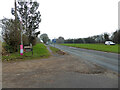
5
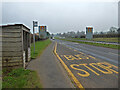
A449 entering Dunhampton
Looking north from alongside the southbound carriageway. The speed limit on this stretch is 50 miles per hour and there are various traffic calming and separation measures as the road had acquired a reputation as a 'killer road'. There have been complaints from some that reducing the limit by 20 MPH has a deleterious effect on traffic between Worcester and Kidderminster and harms trade. I don't see it myself.
Image: © Chris Allen
Taken: 3 Mar 2021
0.06 miles
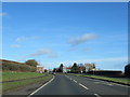
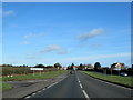
7
Junction of Cow lane and the A449, Sytchampton, Worcestershire
Looking south towards Worcester.
Image: © Chris Allen
Taken: 3 Mar 2021
0.08 miles
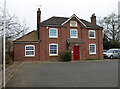
8
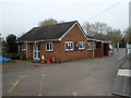
Community Centre, Cow Lane, Sytchampton
Just off the A449 in Worcestershire.
Image: © Chris Allen
Taken: 3 Mar 2021
0.08 miles
9
A449 at Dunhampton
Looking south towards Worcester.
Image: © Chris Allen
Taken: 3 Mar 2021
0.09 miles