IMAGES TAKEN NEAR TO
Larch Way, STOURPORT-ON-SEVERN, DY13 9FE
Introduction
This page details the photographs taken nearby to Larch Way, DY13 9FE by members of the Geograph project.
The Geograph project started in 2005 with the aim of publishing, organising and preserving representative images for every square kilometre of Great Britain, Ireland and the Isle of Man.

There are currently over 7.5m images from over14,400 individuals and you can help contribute to the project by visiting https://www.geograph.org.uk
Image Map
Images are licensed for reuse under creativecommons.org/licenses/by-sa/2.0
Notes
- Clicking on the map will re-center to the selected point.
- The higher the marker number, the further away the image location is from the centre of the postcode.
Image Listing (933 Images Found)
Images are licensed for reuse under creativecommons.org/licenses/by-sa/2.0
Image
Details
Distance
1
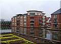
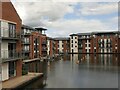
"Water's Edge" new housing development at re-opened canal basin
This is part of the new housing development by the side of the re-opened canal basin. When the development was first being promoted, it was claimed there would be a mix of residential and non-residential buildings. So far nothing non-residential seems to have been built. Maybe these will be built on the land which has not yet been developed? Image;Image
Image: © P L Chadwick
Taken: 29 Dec 2009
0.02 miles
2
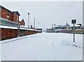
Snow covered junction of Severn & Discovery Roads, Stourport-on-Severn, Worcs
A very heavy snowfall had resulted in this snow scene. Severn Road is in the foreground.
Image: © P L Chadwick
Taken: 24 Jan 2021
0.02 miles
3
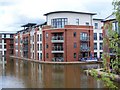
New waterside apartments, Stourport
This previously derelict canal basin has been redeveloped and made the focus for new waterside apartments.
Image: © David Martin
Taken: 7 Aug 2010
0.02 miles
4
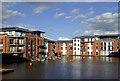
Apartments and moorings in Stourport, Worcestershire
Waters Edge is a Barratt Homes project, apartments completed in 2013 around the (reinstated) Lichfield Basin. After two years it seems very few of the inhabitants utilise the mooring facilities.
Image: © Roger D Kidd
Taken: 29 May 2015
0.02 miles
5
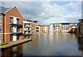
Lichfield Basin, Stourport
Early 21st century residential development.
Image: © Richard Webb
Taken: 7 Jul 2024
0.02 miles
6
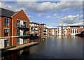
Apartments and moorings in Stourport, Worcestershire
Waters Edge is a Barratt Homes project, apartments completed in 2013 around the (reinstated) Lichfield Basin. After two years it seems very few of the inhabitants require the mooring facilities.
Image: © Roger D Kidd
Taken: 29 May 2015
0.02 miles
7
New apartments by new canal basin, Stourport, Worcestershire
Waters Edge is a Barratt Homes project, apartments completed in 2013 around the (reinstated) Lichfield Basin.
Image: © Roger D Kidd
Taken: 23 Jun 2013
0.03 miles
8
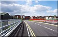
New road over the River Stour, Stourport-on-Severn
Looking in the direction of the new Waters Edge housing development, with the town centre behind it.
Image
Image: © P L Chadwick
Taken: 1 Jul 2012
0.03 miles
9
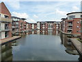
Lichfield Basin, Stourport on Severn
This was part of the inland port at one end of the Staffordshire & Worcestershire Canal. This basin was opened in 1806, filled in during 1950 and partly re-opened in 2007 and surrounded by modern apartment buildings. Although there are moorings in here I don't think I've ever seen a vessel in this basin.
Image: © Chris Allen
Taken: 19 Jun 2017
0.03 miles
10
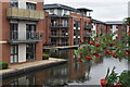
Modern apartments overlooking canal basin, Stourport
For a different view from the same spot, see Image, taken shortly after the development was completed.
Image: © David Martin
Taken: 30 Jul 2022
0.03 miles