
IMAGES TAKEN NEAR TO
Lickhill Road, STOURPORT-ON-SEVERN, DY13 8SL
Introduction
This page details the photographs taken nearby to Lickhill Road, DY13 8SL by members of the Geograph project.
The Geograph project started in 2005 with the aim of publishing, organising and preserving representative images for every square kilometre of Great Britain, Ireland and the Isle of Man.

There are currently over 7.5m images from over14,400 individuals and you can help contribute to the project by visiting https://www.geograph.org.uk
Image Map
Images are licensed for reuse under creativecommons.org/licenses/by-sa/2.0
Notes
- Clicking on the map will re-center to the selected point.
- The higher the marker number, the further away the image location is from the centre of the postcode.
Image Listing (86 Images Found)
Images are licensed for reuse under creativecommons.org/licenses/by-sa/2.0
Image
Details
Distance
1
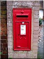
George V wall-mounted postbox, Lickhill Road
This postbox has been here for between about 75 & 100 years, as it dates from the reign of King George V, who reigned 1910-1936. The introduction of new wall-mounted postboxes was abandoned many years ago. This particular example was made by Derby Castings Limited of Derby. Their name appears at the bottom. Image Update:- The postbox is no longer in use and has been painted black. See:- Image
Image: © P L Chadwick
Taken: 31 Dec 2009
0.02 miles
2
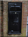
Disused George V wall-mounted letterbox, Lickhill Road, Stourport-on-Severn
At some point after 2009 this postbox ceased to be operational. The posting slot has been sealed up and the box has been painted black. When it was in use the box was number DY13 140 and the post code was DY13 8**. Last posting times in 2009 were 5.30 p.m. Monday to Friday and 9 a.m. on Saturday. It has now become a historical artifact but this photograph shows how it looked when it was in use in December 2009:- Image
Image: © P L Chadwick
Taken: 31 Aug 2015
0.02 miles
3
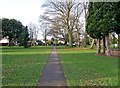
Stourport War Memorial Park - footpath to Lickhill Road
The park was created as a memorial to the 135 men from Stourport-on-Severn who lost their lives in the First World War of 1914-1918. It is sometimes referred to as the War Memorial Gardens. Possibly that was its original name. This path leads from the main gates in Park Avenue to Lickhill Road.
Image: © P L Chadwick
Taken: 31 Dec 2009
0.02 miles
4
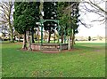
Stourport War Memorial Park - bandstand
The bandstand looks rather strange, having no roof and being hemmed in by a circle of trees. The town has a far more impressive bandstand at Riverside Meadows:- Image
Image: © P L Chadwick
Taken: 31 Dec 2009
0.03 miles
5
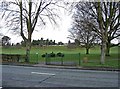
Stourport War Memorial Park - entrance gates on Lickhill Road
A footpath leads from this point to the impressive gates on Park Avenue. Image
Image: © P L Chadwick
Taken: 31 Dec 2009
0.03 miles
6

Poppy wreath, Stourport War Memorial Park, Stourport-on-Severn
The wreath is hung on a recently planted oak tree, which was donated by Stourport Rotary Club. The card attached to it reads: "This oak tree was donated by Stourport Rotary. Remembering those who gave their tomorrows for our todays. In Remembrance." See also:- Image
Image: © P L Chadwick
Taken: 5 Jan 2019
0.04 miles
7
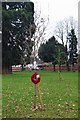
Newly planted oak tree with poppy wreath, Stourport War Memorial Park, Stourport-on-Severn
The oak tree was planted in 2018 and was donated by Stourport Rotary Club. It commemorates those who gave their lives in past wars and of the 100th anniversary of the ending of World War I in November 1918.
See also:- Image
Image: © P L Chadwick
Taken: 5 Jan 2019
0.04 miles
8
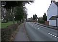
Lickhill Road
On the left is Stourport War Memorial Park, which is a public park. In the far distance, just past the lamppost on the right, is a wall-mounted George V postbox. It can be seen in more detail here:- Image Since these photographs were taken the postbox has been taken out of service and painted black.
Image: © P L Chadwick
Taken: 31 Dec 2009
0.04 miles
9
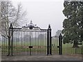
War Memorial Park gates, Park Avenue
The wrought iron park entrance gates, erected to commemorate the 1914-1918 war, are double gates and the design includes the Stourport coat of arms.
Image: © Brian Green
Taken: 10 Jan 2009
0.06 miles
10
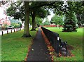
Footpath in Park Avenue, Stourport-on-Severn
The footpath runs adjacent to Stourport War Memorial Park, on the right, and ends at Park Avenue's junction with Lickhill Road. To the right of the black railings is a seat. The bollards to the left of the footpath were recently installed. Their purpose is to deter the unauthorised parking of caravans and other vehicles. A group of people recently parked their caravans, pick-up trucks and cars in the middle of the park and they remained there some time, which caused a lot of local controversy.
Image: © P L Chadwick
Taken: 31 Aug 2015
0.06 miles