
IMAGES TAKEN NEAR TO
Minster Road, STOURPORT-ON-SEVERN, DY13 8AJ
Introduction
This page details the photographs taken nearby to Minster Road, DY13 8AJ by members of the Geograph project.
The Geograph project started in 2005 with the aim of publishing, organising and preserving representative images for every square kilometre of Great Britain, Ireland and the Isle of Man.

There are currently over 7.5m images from over14,400 individuals and you can help contribute to the project by visiting https://www.geograph.org.uk
Image Map
Images are licensed for reuse under creativecommons.org/licenses/by-sa/2.0
Notes
- Clicking on the map will re-center to the selected point.
- The higher the marker number, the further away the image location is from the centre of the postcode.
Image Listing (183 Images Found)
Images are licensed for reuse under creativecommons.org/licenses/by-sa/2.0
Image
Details
Distance
1
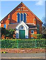
Stourport Baptist Church (2) - Prospect Road entrance, Stourport-on-Severn
The south side of the church and entrance, seen from Prospect Road.
Other photos, please see:- Image
Image: © P L Chadwick
Taken: 23 Apr 2013
0.02 miles
2
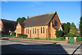
Stourport Baptist Church (1), Minster Road, Stourport-on-Severn
The church is on the corner of Minster Road (the A451) and Prospect Road. Designed by Ingall & Hughes and built in 1883. The church normally has two services on Sundays, and organises many activities in the week, both in the church and elsewhere.
Image
Image
Image
Image: © P L Chadwick
Taken: 23 Apr 2013
0.02 miles
3
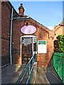
Stourport Baptist Church (4) - Church schoolroom entrance, Minster Road, Stourport-on-Severn
Other photos, please see:- Image
Image: © P L Chadwick
Taken: 23 Apr 2013
0.03 miles
4
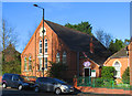
Stourport Baptist Church (3) - Church schoolroom, Minster Road, Stourport-on-Severn
The schoolroom was built next to the church in 1896. It is well used during the week both for church activities and by local community groups.
Other photos, please see:- Image
Image: © P L Chadwick
Taken: 23 Apr 2013
0.04 miles
5
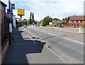
Speed camera along the northbound A451
Image: © Mat Fascione
Taken: 28 Jul 2013
0.09 miles
7
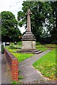
Celtic style cross, corner of Church Drive and Minster Road, Stourport-on-Severn
At first glimpse this fairly large Celtic style cross looks like a war memorial. However it is not but seems to date from around 1844 and commemorates the fact that this area of the town, then known as Lower Mitton, became part of a new ecclesiastical parish. Previously it had been the chapelry of Lower Mitton in the parish of Kidderminster. On the 19th June 1844 Lower Mitton was joined with the adjoining area of Upper Mitton, to form the new ecclesiastical parish of Stourport. Not Stourport-on-Severn it should be noted, as the town didn't get that name until ninety years later in 1934.
That this exciting event should require a memorial to celebrate it, seems rather amazing at this long distance in time, particularly as ecclesiastical parishes these days are being combined rather than sub-divided into new ones. But early Victorian times were very different to ours and it is interesting that this half-forgotten monument should survive, particularly in view of the district council's history of demolishing old structures.
Image
Image
Image: © P L Chadwick
Taken: 19 Aug 2012
0.13 miles
8
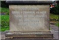
Inscription on base of cross, corner of Church Drive and Minster Road, Stourport-on-Severn
The inscription reads:- "God forbid that I should glory save in the cross of our Lord Jesus Christ". For more about the cross, which probably dates from 1844 or shortly afterwards, please see:- Image
Image
Image: © P L Chadwick
Taken: 19 Aug 2012
0.13 miles
9
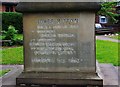
Inscription on base of cross, corner of Church Drive and Minster Road, Stourport-on-Severn
On this side of the base of the cross very little of the inscription can be read. It starts:- "Lower Mitton made a Parish 1844.........". The name Charles seems to appear two lines below, and also the dates 1849 and 1861 can clearly be read. The last line, at least, is possibly in Latin. What is very strange and a little disturbing, is that the illegibility is not primarily due to weathering. Rather someone seems to have deliberately obliterated most of the inscription, possibly with a chisel. Whether this was done at the request of the church authorities, which seems perhaps unlikely, I do not know and so far I have not been able to find out any other information about the history of this cross.
Only one of the other sides of the base has an inscription. See:- Image It is possible that the remaining two sides once had inscriptions, which may perhaps have been concreted over, but this is conjecture.
Image
Image: © P L Chadwick
Taken: 19 Aug 2012
0.13 miles
10
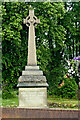
Celtic style cross in Stourport, Worcestershire
This attractive (but not Celtic) cross from the 1840s is by the junction of Church Drive with Minster Road. See https://www.geograph.org.uk/photo/3092124 for more information.
Image]
Image: © Roger Kidd
Taken: 20 Jun 2013
0.13 miles