IMAGES TAKEN NEAR TO
Himley Road, DUDLEY, DY1 2QD
Introduction
This page details the photographs taken nearby to Himley Road, DY1 2QD by members of the Geograph project.
The Geograph project started in 2005 with the aim of publishing, organising and preserving representative images for every square kilometre of Great Britain, Ireland and the Isle of Man.

There are currently over 7.5m images from over14,400 individuals and you can help contribute to the project by visiting https://www.geograph.org.uk
Image Map
Images are licensed for reuse under creativecommons.org/licenses/by-sa/2.0
Notes
- Clicking on the map will re-center to the selected point.
- The higher the marker number, the further away the image location is from the centre of the postcode.
Image Listing (98 Images Found)
Images are licensed for reuse under creativecommons.org/licenses/by-sa/2.0
Image
Details
Distance

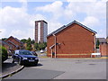
2
Friends Meeting House, Parkway Road, Dudley
Image: © Robin Stott
Taken: 29 Sep 2013
0.03 miles
3
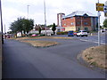
Island View
The view of the Wolverhampton Street Island in Dudley.
Image: © Gordon Griffiths
Taken: 14 Jul 2018
0.03 miles
4
Parkway Road
The view near Grange Park in Dudley.
Image: © Gordon Griffiths
Taken: 14 Jul 2018
0.03 miles
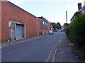
5
Boundary of former industrial sites, northeast end of Parkway Road, Dudley
On OS 1:2500 maps the modern road pattern here is shown from 1903. These sites are marked as Glassworks, left, and Malthouse, right. By the map of 1963-4 both sites are marked as Works but they have plainly fallen derelict since.
Image: © Robin Stott
Taken: 29 Sep 2013
0.04 miles
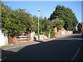
6
Malthouse Drive
The view up the street in Dudley.
Image: © Gordon Griffiths
Taken: 14 Jul 2018
0.05 miles
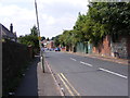
7
Parkway Road View
The view of the road near Grange Park in Dudley.
Image: © Gordon Griffiths
Taken: 14 Jul 2018
0.05 miles
8
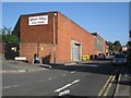
Mister Dave?s, Parkway Road, Dudley
Long established maker and distributor of "restaurant quality" curries http://www.cylex-uk.co.uk/reviews/viewcompanywebsite.aspx?firmaName=mister-daves&companyId=13082507 These premises are on the corner of Himley Road.
Image: © Robin Stott
Taken: 29 Sep 2013
0.05 miles
9
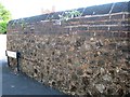
Brick-capped rubble wall, Parkway Road, Dudley
The rubble seems to be a mixture of natural rock and lumps of slag; in some pieces of the latter gas bubbles can be seen Image The brick capping may have been simply to raise the height of the wall, but it may be to protect the lime mortar (presumed) from the weather. A similar wall is seen in Image
Image: © Robin Stott
Taken: 29 Sep 2013
0.06 miles
10
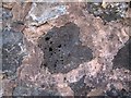
Detail of rubble wall, Parkway Road, Dudley
A close-up of a component of the rubble wall in Image It is assumed to be slag or some other industrial waste material that has been gasified: bubbles of different sizes can be seen here; the piece on the right has more uniform fine bubbles. Could it be slag from glassmaking? There was a glassworks in Parkway Road.
Image: © Robin Stott
Taken: 29 Sep 2013
0.06 miles