IMAGES TAKEN NEAR TO
Kinlet, BEWDLEY, DY12 3BW
Introduction
This page details the photographs taken nearby to DY12 3BW by members of the Geograph project.
The Geograph project started in 2005 with the aim of publishing, organising and preserving representative images for every square kilometre of Great Britain, Ireland and the Isle of Man.

There are currently over 7.5m images from over14,400 individuals and you can help contribute to the project by visiting https://www.geograph.org.uk
Image Map (6 Images)


Getting Data...Please wait
Leaflet Map data © OpenStreetMap
Images are licensed for reuse under creativecommons.org/licenses/by-sa/2.0
Notes
- Clicking on the map will re-center to the selected point.
- The higher the marker number, the further away the image location is from the centre of the postcode.
Image Listing (6 Images Found)
Images are licensed for reuse under creativecommons.org/licenses/by-sa/2.0
Image
Details
Distance
1
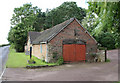
The Old Forge, by the B4363 at Pancake Farm
Image: © Robert Caldicott
Taken: 4 Jul 2007
0.01 miles
4
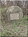
Old Milestone by the B4363, south of Pancake Farm, Kinlet parish
Metal plate attached to stone post by the B4363, in parish of KINLET (BRIDGNORTH District), 200m South Pancake Farm, at base of hedgerow, on West side of road. Cleobury iron plate, erected by the Cleobury Mortimer to Bridgnorth turnpike trust in the 19th century.
Inscription reads:-
BRIDGNORTH
9 MILES
CLEOBURY MORTR
5 MILES
Carved benchmark front top right and rivet.
Shropshire HER.
HER Number (PRN): 21117 https://www.heritagegateway.org.uk/Gateway/Results_Single.aspx?uid=MSA23690&resourceID=1015
Milestone Society National ID: SA_BNCM09.
Image: © A Reade/M Faherty
Taken: 8 Feb 2008
0.15 miles
5
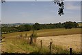
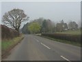
Fields, Kinlet
The ground slopes away to the River Severn, as a result tributary streams have cut deep valleys which are often wooded. One such woodland is visible in the background.
Image: © Richard Webb
Taken: 3 Jul 2018
0.19 miles
6
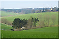
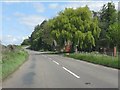
Fields & church
Mixed fields of grazing & crop with Kinlet church.
Image: © Neil Owen
Taken: 9 Apr 2007
0.20 miles