IMAGES TAKEN NEAR TO
Dowles Brook, BEWDLEY, DY12 2LY
Introduction
This page details the photographs taken nearby to Dowles Brook, DY12 2LY by members of the Geograph project.
The Geograph project started in 2005 with the aim of publishing, organising and preserving representative images for every square kilometre of Great Britain, Ireland and the Isle of Man.

There are currently over 7.5m images from over14,400 individuals and you can help contribute to the project by visiting https://www.geograph.org.uk
Image Map
Images are licensed for reuse under creativecommons.org/licenses/by-sa/2.0
Notes
- Clicking on the map will re-center to the selected point.
- The higher the marker number, the further away the image location is from the centre of the postcode.
Image Listing (80 Images Found)
Images are licensed for reuse under creativecommons.org/licenses/by-sa/2.0
Image
Details
Distance
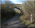
1

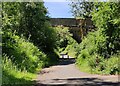
Bridge over former railway line, Bewdley
The bollards mark the limit of vehicular traffic on the other side of the bridge where the access turns to the left (seen from this side). The bridge now carries a footpath.
Image: © Chris Allen
Taken: 26 Jan 2022
0.05 miles
2
National Cycle Route 45 in the Wyre Forest
Following the route of a former railway line.
The Wyre Forest measures 26.34 square kilometres (10.17 sq mi), it straddles the border of Worcestershire and Shropshire. It is one of the largest areas of semi-natural (partially unmanaged) woodland in the UK.
Image: © Mat Fascione
Taken: 9 Jul 2022
0.05 miles
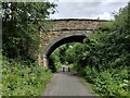
3
Bridge crossing a former railway line
The bridge crosses National Cycle Route 45 which follows the route of the former Tenbury and Bewdley Railway, which closed to passenger trains in 1962 and goods traffic in 1965.
Wyre Forest covers an area of 26.34 square kilometres (10.17 sq mi), it straddles the borders of Worcestershire and Shropshire.
Image: © Mat Fascione
Taken: 28 Oct 2022
0.05 miles
4
Bridge across a former railway line
National Cycle Route 45 follows the route of the former Tenbury and Bewdley Railway, which closed to passenger trains in 1962 and goods traffic in 1965.
Wyre Forest covers an area of 26.34 square kilometres (10.17 sq mi), it straddles the borders of Worcestershire and Shropshire.
Image: © Mat Fascione
Taken: 5 Jul 2023
0.05 miles
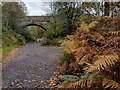
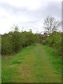
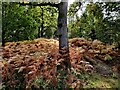
5
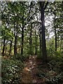
Path through the Wyre Forest
Wyre Forest covers an area of 26.34 square kilometres (10.17 sq mi), it straddles the borders of Worcestershire and Shropshire.
Image: © Mat Fascione
Taken: 9 Oct 2022
0.05 miles
6
Wyre Forest NNR, path over former railway line by Lodge Hill Farm
Image: © Liz Stone
Taken: 11 May 2012
0.05 miles
7
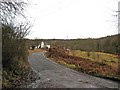
Road to Lodge Hill Farm
The road to Lodge Hill Farm is a turning off the road laid over part of the former Bewdley to Tenbury & Woofferton railway. These roads are not open to unauthorised vehicles. Next to the farmhouse English Nature have an office.
Image: © P L Chadwick
Taken: 2 Feb 2010
0.06 miles
8
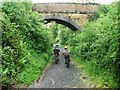
Cycle path through Wyre Forest
The cycle path, part of National Route 45, uses the trackbed of the disused Tenbury and Bewdley railway which closed in 1964. The bridge is just south of Lodge Hill Farm.
Image: © Simon Mortimer
Taken: 25 May 2008
0.06 miles
9
Bridge across National Cycle Route 45
Near Lodge Hill Farm in the heart of the Wyre Forest.
The Wyre Forest measures 26.34 square kilometres (10.17 sq mi), it straddles the border of Worcestershire and Shropshire. It is one of the largest areas of semi-natural (partially unmanaged) woodland in the UK.
Image: © Mat Fascione
Taken: 24 Feb 2017
0.07 miles
10
Wyre Forest next to National Cycle Route 45
Wyre Forest covers an area of 26.34 square kilometres (10.17 sq mi), it straddles the borders of Worcestershire and Shropshire.
Image: © Mat Fascione
Taken: 9 Oct 2022
0.07 miles