IMAGES TAKEN NEAR TO
Pinetree Road, BEWDLEY, DY12 2JD
Introduction
This page details the photographs taken nearby to Pinetree Road, DY12 2JD by members of the Geograph project.
The Geograph project started in 2005 with the aim of publishing, organising and preserving representative images for every square kilometre of Great Britain, Ireland and the Isle of Man.

There are currently over 7.5m images from over14,400 individuals and you can help contribute to the project by visiting https://www.geograph.org.uk
Image Map
Images are licensed for reuse under creativecommons.org/licenses/by-sa/2.0
Notes
- Clicking on the map will re-center to the selected point.
- The higher the marker number, the further away the image location is from the centre of the postcode.
Image Listing (37 Images Found)
Images are licensed for reuse under creativecommons.org/licenses/by-sa/2.0
Image
Details
Distance
1
Wyre Cottage, Bewdley
An old gem now surrounded by housing estates.
Image: © Jeremy Bolwell
Taken: 26 Nov 2012
0.05 miles
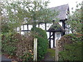
2
Wyre Court in Bewdley
Dating from the late 16th century with later extensions and alterations. Now converted into apartments. Along Wyre Hill in Bewdley.
Image: © Mat Fascione
Taken: 9 Jul 2022
0.05 miles
3
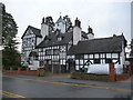
Wyre Court, Bewdley
One of two old properties on Wyre Hill, now surrounded by housing estates. This one has a timber-framed core and Victorian additions.
Image: © Jeremy Bolwell
Taken: 26 Nov 2012
0.06 miles
4
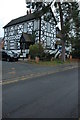
Wyre Court
Interesting looking house on the edge of Bewdley, the wing behind the tree appears to be older, with a later building adjoining which has a facia to make it appear older.
Image: © Philip Halling
Taken: 1 Nov 2008
0.06 miles
5
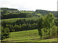
Looking south west from the outskirts of Bewdley
The view extends across the Bewdley bypass (unseen in between the dark trees mid-frame). The buildings on the upper left are on the S edge of the square at 772740 surrounded by Wharton Park Golf Course. Top right is the edge of Rock Coppice in the next square.
Image: © Richard Greenwood
Taken: 24 Sep 2006
0.10 miles
6
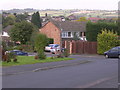
Hales Park Estate, Bewdley
1960's housing looking North across Hales Park estate towards Bark Hill estate (red rooves, right) and The Lakes Estate (centre left). On the 1940's OS Map much of this area was cherry and other fruit orchards. Now all that remain are street names of cherry varieties, Morello Close, Ironside Close, Early River Place, although it is possible to find the occasional old fruit tree in back gardens.
Image: © Richard Greenwood
Taken: 8 Oct 2006
0.11 miles
8

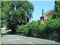
Wyre Hill, Bewdley, Worcs
A section of this long road, with its mix of old & new buildings. In this direction it is heading out of town.
Image: © P L Chadwick
Taken: 27 Mar 2021
0.11 miles
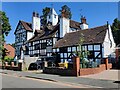
10

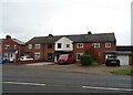
Hop Pole Inn, Bewdley
The Hop Pole Inn and Restaurant in Bewdley.
Image: © Philip Halling
Taken: 1 Nov 2008
0.13 miles