IMAGES TAKEN NEAR TO
Park Close, BEWDLEY, DY12 2EN
Introduction
This page details the photographs taken nearby to Park Close, DY12 2EN by members of the Geograph project.
The Geograph project started in 2005 with the aim of publishing, organising and preserving representative images for every square kilometre of Great Britain, Ireland and the Isle of Man.

There are currently over 7.5m images from over14,400 individuals and you can help contribute to the project by visiting https://www.geograph.org.uk
Image Map (Loading...)


Getting Data...Please wait
Leaflet Map data © OpenStreetMap
Images are licensed for reuse under creativecommons.org/licenses/by-sa/2.0
Notes
- Clicking on the map will re-center to the selected point.
- The higher the marker number, the further away the image location is from the centre of the postcode.
Image Listing (654 Images Found)
Images are licensed for reuse under creativecommons.org/licenses/by-sa/2.0
Image
Details
Distance
1
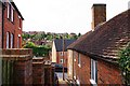
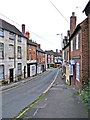
Park Lane, Bewdley, Worcs
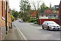
Park Lane makes a very steep ascent. Driving up this hill is not for the faint-hearted! The Road coming in on the left is Park Close. That coming in on the right is Orchard Rise, both of these are cul-de-sacs.
Image: © P L Chadwick
Taken: 10 Apr 2022
0.04 miles
2
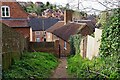
Fork in footpath in woods, Bewdley, Worcs
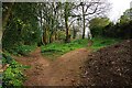
The wooded area high above parts of Park Lane and High Street has several footpaths. Behind the camera position the footpath descends to Park Lane.
Image: © P L Chadwick
Taken: 10 Apr 2022
0.04 miles
3
Ramped passageway from Park Lane, Bewdley, Worcs
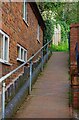
This steep passageway leads from Park Lane up to the wooded area above parts of Park Lane and High Street. The passageway is in the form of a tiled ramp rather than steps. Fortunately there is a sturdy handrail.
Image
Image: © P L Chadwick
Taken: 10 Apr 2022
0.05 miles
4
Metal gate giving access to Park Lane, Bewdley, Worcs
The gate gives access to the ramped passageway leading down to Park Lane.
See also:- Image
Image: © P L Chadwick
Taken: 10 Apr 2022
0.05 miles
5
Park Lane seen from the woods above, Bewdley, Worcs
A view towards Park Lane from the metal gate giving access to the ramped passageway. This passageway connects the wooded area above parts of Park Lane and High Street to Park Lane.
See also:- Image
Image: © P L Chadwick
Taken: 10 Apr 2022
0.05 miles
7
Church House along Bewdley High Street
Image: © Mat Fascione
Taken: 25 Nov 2020
0.07 miles
8
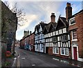
Welch Gate (lower end)
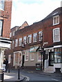
Welch Gate is a very old and winding road which climbs steeply from Bewdley's town centre to the point where it joins the road known as Winbrook. Welch Gate gets its name from the old tollgate which once stood on the route from Wales. This view is looking towards the town centre. The building on the left has what appears to be a bricked in window, which may have been done possibly in the 18th century when many windows were removed to avoid the "window tax" introduced in 1696 and not removed until early Victorian times.
Image: © P L Chadwick
Taken: 3 Feb 2008
0.07 miles
9
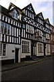
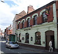
Bailiffs House, Bewdley
Timber-framed Jacobean house dating from 1610, from a distance the house appears to be a pub with an inn-style sign depicting a portrait of King James I of England and VI of Scotland.
Image: © Philip Halling
Taken: 1 Nov 2008
0.07 miles