IMAGES TAKEN NEAR TO
The Village, KIDDERMINSTER, DY11 7TD
Introduction
This page details the photographs taken nearby to The Village, DY11 7TD by members of the Geograph project.
The Geograph project started in 2005 with the aim of publishing, organising and preserving representative images for every square kilometre of Great Britain, Ireland and the Isle of Man.

There are currently over 7.5m images from over14,400 individuals and you can help contribute to the project by visiting https://www.geograph.org.uk
Image Map (Loading...)


Getting Data...Please wait
Leaflet Map data © OpenStreetMap
Images are licensed for reuse under creativecommons.org/licenses/by-sa/2.0
Notes
- Clicking on the map will re-center to the selected point.
- The higher the marker number, the further away the image location is from the centre of the postcode.
Image Listing (47 Images Found)
Images are licensed for reuse under creativecommons.org/licenses/by-sa/2.0
Image
Details
Distance
4
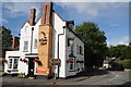
The White Hart, Hartlebury
The White Hart stands on a road junction opposite Hartlebury church.
Image: © Philip Halling
Taken: 7 Aug 2011
0.06 miles

7

The White Hart, Hartlebury
See also https://www.geograph.org.uk/photo/3614963 from 2013, from a different angle.
Image: © Mike Dodman
Taken: 17 Sep 2024
0.06 miles

10
View to the White Hart
The view down Quarry Bank to the White Hart on the B4193 road junction, opposite Hartlebury church.
Image: © Gordon Griffiths
Taken: 7 Sep 2016
0.07 miles