IMAGES TAKEN NEAR TO
Rifle Range Road, KIDDERMINSTER, DY11 7NW
Introduction
This page details the photographs taken nearby to Rifle Range Road, DY11 7NW by members of the Geograph project.
The Geograph project started in 2005 with the aim of publishing, organising and preserving representative images for every square kilometre of Great Britain, Ireland and the Isle of Man.

There are currently over 7.5m images from over14,400 individuals and you can help contribute to the project by visiting https://www.geograph.org.uk
Image Map
Images are licensed for reuse under creativecommons.org/licenses/by-sa/2.0
Notes
- Clicking on the map will re-center to the selected point.
- The higher the marker number, the further away the image location is from the centre of the postcode.
Image Listing (33 Images Found)
Images are licensed for reuse under creativecommons.org/licenses/by-sa/2.0
Image
Details
Distance
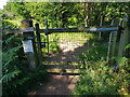
1
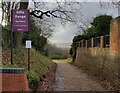
Entrance to the Rifle Range Nature Reserve
At the end of Rifle Range Road.
Image: © Mat Fascione
Taken: 4 Jan 2023
0.02 miles
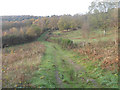
2
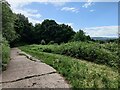
Tarmac track to the Rifle Range Nature Reserve
Image: © Mat Fascione
Taken: 21 Jun 2023
0.04 miles
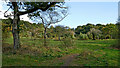
3
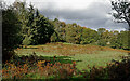
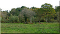
Rifle Range Nature Reserve near Kidderminster, Worcestershire
This is part of the Rifle Range Nature Reserve, seen by looking south-east from near Whitehill Wood. Woodland ahead is part of Gorse Covert. Some areas of the reserve are fenced (but still accessible) to enable grazing of Highland cattle (part of the heathland preservation and maintenance), though I didn't see any.
Image: © Roger Kidd
Taken: 15 Oct 2020
0.11 miles
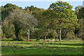
4
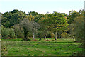
Grass and woodland near Sutton Farm, Kidderminster
Looking south-east, this shows one of the grassy areas on the Rifle Range Nature Reserve between Kidderminster and Bewdley. There are several public footpaths and a bridleway crossing the reserve, as well as many other interesting tracks to explore. This applies across the adjacent Devil's Spittleful reserve.
Image: © Roger Kidd
Taken: 15 Oct 2020
0.14 miles
5
Grass and woodland west of Sutton Farm, Kidderminster
Looking east, this shows one of the grassy areas on the Rifle Range Nature Reserve between Kidderminster and Bewdley.
Image: © Roger Kidd
Taken: 15 Oct 2020
0.14 miles
6
Entrance to Rifle Range Nature Reserve
Image: © Jeff Gogarty
Taken: 23 Jun 2022
0.14 miles
8
Woodland clearing in the Rifle Range Nature Reserve, Worcestershire
A grassy opening in the trees, looking south-east towards Gorse Covert.
Image: © Roger Kidd
Taken: 15 Oct 2020
0.16 miles
9
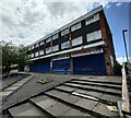
Closed shops on Severn Grove, Kidderminster
Image: © Mat Fascione
Taken: 21 Jun 2023
0.16 miles
10
Rifle Range Nature Reserve near Kidderminster
Looking east-south-east, this shows one of the grassy areas on the Rifle Range Nature Reserve between Kidderminster and Bewdley. There are several public footpaths and a bridleway crossing the reserve, as well as many other interesting tracks to explore. This continues across the adjacent Devil's Spittleful reserve.
Image: © Roger Kidd
Taken: 15 Oct 2020
0.16 miles