IMAGES TAKEN NEAR TO
Elmfield Road, KIDDERMINSTER, DY11 7LA
Introduction
This page details the photographs taken nearby to Elmfield Road, DY11 7LA by members of the Geograph project.
The Geograph project started in 2005 with the aim of publishing, organising and preserving representative images for every square kilometre of Great Britain, Ireland and the Isle of Man.

There are currently over 7.5m images from over14,400 individuals and you can help contribute to the project by visiting https://www.geograph.org.uk
Image Map
Images are licensed for reuse under creativecommons.org/licenses/by-sa/2.0
Notes
- Clicking on the map will re-center to the selected point.
- The higher the marker number, the further away the image location is from the centre of the postcode.
Image Listing (11 Images Found)
Images are licensed for reuse under creativecommons.org/licenses/by-sa/2.0
Image
Details
Distance
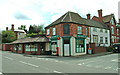
1
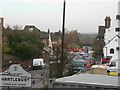
Hartlebury Garage, Worcester Road, Hartlebury
Hartlebury Garage are a family run business with over 40 years experience of the famous Morgan sports cars for both road and competition use. They are the Morgan factory appointed agent for the Midlands area. Morgan cars are made about twenty miles away in Malvern, Worcestershire.
Image: © P L Chadwick
Taken: 26 Feb 2012
0.18 miles
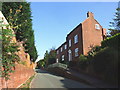
2
Old cottages in Inn Lane, Hartlebury
These attractive cottages are in Inn Lane in the village of Hartlebury.
Image: © P L Chadwick
Taken: 13 Jul 2008
0.22 miles
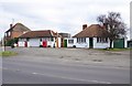
3
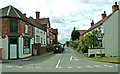
Hartlebury Post Office, corner of Inn Lane & Worcester Road, Hartlebury
This group of buildings includes on the far left a hairdressers plus a convenience store and the local Post Office. The road off to the right is Inn Lane.
Image: © P L Chadwick
Taken: 13 Jul 2008
0.22 miles
5
Hartlebury
The Talbot pub is opposite the post office.
Image: © Jennifer Luther Thomas
Taken: 1 Dec 2006
0.23 miles
6
Inn Lane, Hartlebury
This long road connects Worcester Road and Rectory Lane. It contains some of the most expensive residential properties in the area. It comes out onto Worcester Road very near The Talbot public house. But the name probably originates from the fact that there was at least one inn in Inn Lane itself at one time.
Image: © P L Chadwick
Taken: 13 Jul 2008
0.23 miles
7
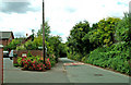
Inn Lane, Hartlebury
This view is of a section of the long road known as Inn Lane in the village of Hartlebury. On the left there is the start of a public footpath which leads to the road known as Quarry Bank.
Image: © P L Chadwick
Taken: 13 Jul 2008
0.24 miles
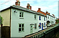
8
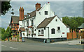
The Talbot, Worcester Road, Hartlebury
One of the two public houses in the village of Hartlebury which are still open, The Talbot is to be found in the village itself, not on the A449. The pub is the oldest in the village and dates from the early 17th century, when it was a farmhouse. When it became an inn, it went under the name of The Dog Inn for many years. Its sign was a white dog and the adjacent old turnpike road became known as Dog Lane. In the early 19th century it was known for a while as the Dealers' Inn. An inventory from 1911 refers to iron spittoons in the taproom, snuff boxes in the smoke room and a collection of 950 clay pipes.
Image
Update March 2017:- The pub is to be converted into housing. Image
Image: © P L Chadwick
Taken: 13 Jul 2008
0.24 miles
9
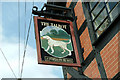
The Talbot pub sign, Worcester Road, Hartlebury
This public house is part of the Enterprise Inns Group which now has over 7,000 establishments. It's strange that although the Talbot Hound as a breed of dog has been extinct for a very long time, there are still hundreds of pubs and hotels named after it.
Image
Update March 2017:- The pub closed in 2010 and will now be converted into residential use.
Image: © P L Chadwick
Taken: 13 Jul 2008
0.24 miles