IMAGES TAKEN NEAR TO
Jubilee Drive, KIDDERMINSTER, DY11 7JE
Introduction
This page details the photographs taken nearby to Jubilee Drive, DY11 7JE by members of the Geograph project.
The Geograph project started in 2005 with the aim of publishing, organising and preserving representative images for every square kilometre of Great Britain, Ireland and the Isle of Man.

There are currently over 7.5m images from over14,400 individuals and you can help contribute to the project by visiting https://www.geograph.org.uk
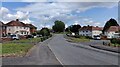
Image Map (Loading...)


Getting Data...Please wait
Leaflet Map data © OpenStreetMap
Images are licensed for reuse under creativecommons.org/licenses/by-sa/2.0
Notes
- Clicking on the map will re-center to the selected point.
- The higher the marker number, the further away the image location is from the centre of the postcode.
Image Listing (17 Images Found)
Images are licensed for reuse under creativecommons.org/licenses/by-sa/2.0
Image
Details
Distance
2
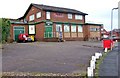
The Musketeer, Avon Road, Kidderminster
This is the estate pub for the Rifle Range Estate. The pub also has an off-licence.
Image: © P L Chadwick
Taken: 11 Jan 2009
0.10 miles
3
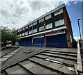
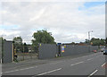
Closed shops on Severn Grove, Kidderminster
Image: © Mat Fascione
Taken: 21 Jun 2023
0.12 miles
4
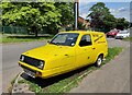
Reliant Realto on Goldthorn Road, Kidderminster
Image: © Mat Fascione
Taken: 21 Jun 2023
0.16 miles
5
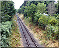
Severn Valley Railway heading towards Bewdley
Image: © Mat Fascione
Taken: 28 Jul 2013
0.16 miles
6
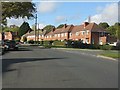
Birchen Coppice estate at Wrekin Close
Image: © Peter Whatley
Taken: 26 Oct 2011
0.19 miles
7
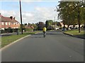
Easy rider on Birchen Coppice estate
School half-term and it's time to ride a bike down the middle of the road with your iPod on, blissfully unaware of possible consequences.
Image: © Peter Whatley
Taken: 26 Oct 2011
0.19 miles
8
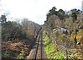
Severn Valley Railway line near Stourport Road, Kidderminster
The heritage railway line is seen here heading towards Bridgnorth via Bewdley. The building on the right is marked on the map as Railway Cottage, so may have been connected with the railway long ago. Photographed from the bridge over the railway in Stourport Road (the A451).
Image
Image: © P L Chadwick
Taken: 18 Mar 2013
0.21 miles
9
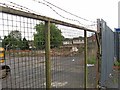
Site of the demolished Sutton Arms pub, 195 Sutton Park Road, Kidderminster
The pub had been under threat for a long time. By September 2010, it was virtually all demolished, although the pub's sign, attached to a post, was still standing. As so often happens, the large site will be used for yet more housing, leaving this part of the town with very few facilities.
Some more pictures:-
Image
Image
Image
The pub when still open:- Image
Image: © P L Chadwick
Taken: 15 Sep 2010
0.23 miles
10
Another Kidderminster pub bites the dust
All that remains of The Sutton Arms, is a small section of wall, which can be seen still standing, and the pub's sign, which remains attached to its post. The houses in the distance are in Parry Road. The site is due to be used for building new houses. Photographed from the pavement in Sutton Park Road.
Links to more pictures, past and present:- Image
Image: © P L Chadwick
Taken: 15 Sep 2010
0.23 miles