IMAGES TAKEN NEAR TO
Lisle Avenue, KIDDERMINSTER, DY11 7DN
Introduction
This page details the photographs taken nearby to Lisle Avenue, DY11 7DN by members of the Geograph project.
The Geograph project started in 2005 with the aim of publishing, organising and preserving representative images for every square kilometre of Great Britain, Ireland and the Isle of Man.

There are currently over 7.5m images from over14,400 individuals and you can help contribute to the project by visiting https://www.geograph.org.uk
Image Map
Images are licensed for reuse under creativecommons.org/licenses/by-sa/2.0
Notes
- Clicking on the map will re-center to the selected point.
- The higher the marker number, the further away the image location is from the centre of the postcode.
Image Listing (52 Images Found)
Images are licensed for reuse under creativecommons.org/licenses/by-sa/2.0
Image
Details
Distance
1
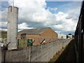
Entering Kidderminster
Taken from the Severn Valley Railway.
Image: © Ian S
Taken: 17 Sep 2011
0.05 miles
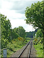
2
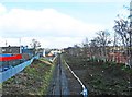
Severn Valley Railway line near Stourport Road, Kidderminster
Viewed from the bridge over the railway line in Stourport Road (the A451), the line is seen here heading for its terminus at Kidderminster, next to the Network Rail station.
Image
Image: © P L Chadwick
Taken: 18 Mar 2013
0.06 miles
3
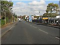
Stourport Road from the railway bridge crest
Image: © Peter Whatley
Taken: 26 Oct 2011
0.07 miles
5
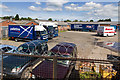
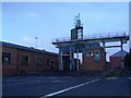
Lorry Yard
A commercial yard for parking vehicles off Lisle Avenue.
Taken from the Severn Valley Railway.
Image: © David P Howard
Taken: 15 May 2014
0.08 miles
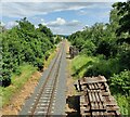
6
Railway near Foley Park in Kidderminster, Worcestershire
This is the Severn Valley Railway near Foley Park and looking south-west towards Bewdlwy and Bridgnorth. https://svr.co.uk/
Image: © Roger Kidd
Taken: 14 May 2014
0.09 miles
7
Severn Valley Railway at Foley Park, Kidderminster
Viewed from the Stourport Road bridge.
Image: © Mat Fascione
Taken: 21 Jun 2023
0.10 miles
8
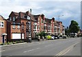
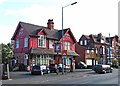
Terrace of housing, Stourport Road, Kidderminster
Stourport Road has a wide variety of housing types along its considerable length. This terrace is still mainly but not exclusively in residential use. Its ends on the corner of Beauchamp Avenue.
Image: © P L Chadwick
Taken: 8 Jun 2014
0.10 miles
9
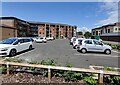
Apartments on Felix Baxter Drive, Kidderminster
Image: © Mat Fascione
Taken: 21 Jun 2023
0.12 miles
10
Park Inn (1), 409 Stourport Road, Kidderminster
Not to be confused with the food focused Park Gate Inn on Stourbridge Road, just outside the town. The Park Inn in Stourport Road is very much a local pub. Possibly not for much longer, as currently (October 2011) there is a planning application before the Council to demolish it. The applicant wishes to replace it with a pet shop & veterinary surgery, with two flats (each with two bedrooms) above. If this is passed, not only will it mean 22 car parking spaces, instead of the present six, thus increasing the nightmare traffic on this road, it will also remove one of the last of the few pubs in this area.
Update June 2012: In the last few days this building has been completely demolished to make way for the new development outlined above. At this rate Kidderminster will soon have more veterinary surgeries than dogs!
Image
Update June 2014:- the new building occupied, see: Image
Image: © P L Chadwick
Taken: 16 Oct 2011
0.12 miles