IMAGES TAKEN NEAR TO
Stourport Road, KIDDERMINSTER, DY11 7BB
Introduction
This page details the photographs taken nearby to Stourport Road, DY11 7BB by members of the Geograph project.
The Geograph project started in 2005 with the aim of publishing, organising and preserving representative images for every square kilometre of Great Britain, Ireland and the Isle of Man.

There are currently over 7.5m images from over14,400 individuals and you can help contribute to the project by visiting https://www.geograph.org.uk
Image Map (Loading...)


Getting Data...Please wait
Leaflet Map data © OpenStreetMap
Images are licensed for reuse under creativecommons.org/licenses/by-sa/2.0
Notes
- Clicking on the map will re-center to the selected point.
- The higher the marker number, the further away the image location is from the centre of the postcode.
Image Listing (209 Images Found)
Images are licensed for reuse under creativecommons.org/licenses/by-sa/2.0
Image
Details
Distance
1

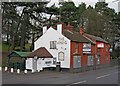
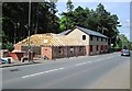
Back of the former Wrens Nest, 46 Stourport Road, Kidderminster
This rather scruffy looking pub had closed by early 2011. Later it was sold for conversion to residential use. In December 2012, when this photograph was taken, work had just or was about to commence on renovating and extending it. Eight months later this work is still proceeding. Photographed from Brinton Park.
Image
Update June 2014:- Image
Image: © P L Chadwick
Taken: 9 Dec 2012
0.00 miles
2
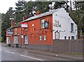
The Wrens Nest (1), 46 Stourport Road, Kidderminster
Recently closed and put up for sale. It has a long history, as in the 1881 Census it is shown as the Wrens Nest Beerhouse. It could even be a bit older than that. In recent years it seems to have been known as The Wrens, but the sign still says The Wrens Nest. The green structure appears to be a smoking shelter. The original shelter was burned down in a fire in April 2010.
Image
Image
Update June 2014:- Image
Image: © P L Chadwick
Taken: 27 Feb 2011
0.01 miles
3
The Wrens Nest (2), 46 Stourport Road, Kidderminster
Recently closed and currently up for sale. It would be surprising if it re-opened as a pub, as the location is not very good, the car park small and it suffers from competition from the nearby and much larger Watermill. In recent years the Wrens Nest has had a rather chequered reputation and seems to have been dying on its feet for some time. Probably trade was not helped by the widely reported brawl in the pub's car park some years ago between some inebriated customers, which sadly resulted in the death of one of them.
Image
Image
Image: © P L Chadwick
Taken: 27 Feb 2011
0.01 miles
4
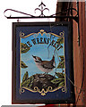
The Wrens Nest (3) - sign, 46 Stourport Road, Kidderminster
The sign of The Wrens Nest, which recently seems to have been abbreviated to The Wrens, although not on this sign. Unfortunately loose cables were dangling over both sides of the sign, partially obscuring it. This was the better side.
Image
Image
Image: © P L Chadwick
Taken: 27 Feb 2011
0.01 miles
5
Conversion work underway on former Wrens Nest (1), 46 Stourport Road, Kidderminster
The conversion of this former public house to residential use has been proceeding for about eighteen months so far, and is not yet complete. Conversion is perhaps the wrong word, as so much has been removed that only a small proportion of the original building remains.
Image
Earlier photographs:-
Image
Image
Image: © P L Chadwick
Taken: 8 Jun 2014
0.01 miles
6
Conversion work underway on former Wrens Nest (2), 46 Stourport Road, Kidderminster
Only a small portion of the former public house remains in this conversion to residential use. See:- Image
Earlier photographs:-
Image
Image
Image: © P L Chadwick
Taken: 8 Jun 2014
0.01 miles
8
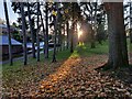
Trees along the southern edge of Brinton Park
Image: © Mat Fascione
Taken: 15 Nov 2020
0.03 miles
9
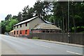
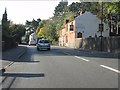
Larches Road, Kidderminster
A residential road which ascends quite steeply from its junction with Stourport Road (the A451).
Image: © P L Chadwick
Taken: 8 Jun 2014
0.05 miles
10
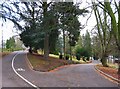
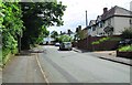
Road junction in Brinton Park, Kidderminster
The road on the left comes out on Park Lane. The other comes out on Stourport Road (A451). For the public these are paths but authorised vehicles can use them. The one on the left can be partially accessed by the public with road vehicles and for all its length by cyclists. A red car can be seen in the distance parked near a barrier across the road.
Image: © P L Chadwick
Taken: 9 Dec 2012
0.05 miles