IMAGES TAKEN NEAR TO
Mill Lane, KIDDERMINSTER, DY11 6YJ
Introduction
This page details the photographs taken nearby to Mill Lane, DY11 6YJ by members of the Geograph project.
The Geograph project started in 2005 with the aim of publishing, organising and preserving representative images for every square kilometre of Great Britain, Ireland and the Isle of Man.

There are currently over 7.5m images from over14,400 individuals and you can help contribute to the project by visiting https://www.geograph.org.uk
Image Map
Images are licensed for reuse under creativecommons.org/licenses/by-sa/2.0
Notes
- Clicking on the map will re-center to the selected point.
- The higher the marker number, the further away the image location is from the centre of the postcode.
Image Listing (130 Images Found)
Images are licensed for reuse under creativecommons.org/licenses/by-sa/2.0
Image
Details
Distance
2

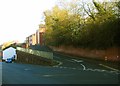
16 wheelie bins
Next to the Proud Cross Ringway in Kidderminster.
Image: © Mat Fascione
Taken: 12 Nov 2022
0.01 miles
4
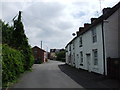
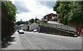
Mill Lane, Kidderminster
Mill Lane ascends rapidly after leaving its junction with Mill Street. Photographed from Mill Street.
Image: © P L Chadwick
Taken: 23 Apr 2013
0.01 miles
5
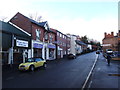
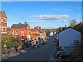
Mill Street, Kidderminster
This street leads down to the Crossley Retail Park.
Image: © Mat Fascione
Taken: 14 Jul 2007
0.02 miles
6
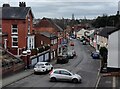
Mill Street, Kidderminster
A mainly commercial road, photographed from Mill Lane.
Image: © P L Chadwick
Taken: 23 Apr 2013
0.02 miles
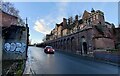
7
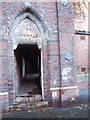
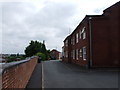
The Dispensary at the old Kidderminster Infirmary
Image: © Chris Whippet
Taken: 24 Dec 2013
0.02 miles
9
The former Mill Street Infirmary
Now converted into apartments.
Image: © Mat Fascione
Taken: 15 Nov 2020
0.03 miles