IMAGES TAKEN NEAR TO
Mill Street, KIDDERMINSTER, DY11 6XG
Introduction
This page details the photographs taken nearby to Mill Street, DY11 6XG by members of the Geograph project.
The Geograph project started in 2005 with the aim of publishing, organising and preserving representative images for every square kilometre of Great Britain, Ireland and the Isle of Man.

There are currently over 7.5m images from over14,400 individuals and you can help contribute to the project by visiting https://www.geograph.org.uk
Image Map (Loading...)


Getting Data...Please wait
Leaflet Map data © OpenStreetMap
Images are licensed for reuse under creativecommons.org/licenses/by-sa/2.0
Notes
- Clicking on the map will re-center to the selected point.
- The higher the marker number, the further away the image location is from the centre of the postcode.
Image Listing (428 Images Found)
Images are licensed for reuse under creativecommons.org/licenses/by-sa/2.0
Image
Details
Distance
1
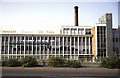
Carpet Factory, Kidderminster
According to Colin Bowden and the book "Woven in Kidderminster" by M Thompson this was built in 1962 for Carpet Trades Ltd and replaced an earlier building. This became Gilt Edge Carpets in 1967 and it appears Crossley & Kosset were also later involved. It was apparently demolished within 30 years of its construction.
Image: © Chris Allen
Taken: 16 Aug 1987
0.02 miles
2
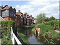
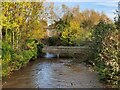
River Stour flowing behind properties in Mill Street
Image: © John M
Taken: 18 May 2008
0.02 miles
3
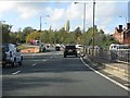
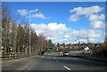
Kidderminster ring road rising toward Blakebrook
Image: © Peter Whatley
Taken: 26 Oct 2011
0.03 miles
6
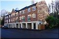
Modern apartment block, Mill Street, Kidderminster, Worcs
This block of residential apartments was built in the last few years.
Image: © P L Chadwick
Taken: 1 Dec 2019
0.04 miles
7
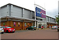
Currys & P C World, Carpet Trades Way, Crossley Retail Park, Kidderminster
Currys & P C World are part of the same group. They used to have separate stores on this retail park. In May 2011 the two stores were merged into what is described as a two-in-one superstore, on the site previously occupied by Currys. The upstairs floor is occupied by white goods and other electrical items sold by Currys, but the ground floor is devoted to computer items, and audio and video, including TV's and cameras. The old PC World store has been closed. It seems this merger process is likely to be carried out across the country, presumably leaving a trail of yet more empty shop units.
Image: © P L Chadwick
Taken: 21 May 2011
0.05 miles
9
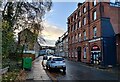
Park Lane, Kidderminster
The steps on the left lead up to the terrace on Hill Street above.
Image: © Chris Whippet
Taken: 22 Jun 2011
0.06 miles
10
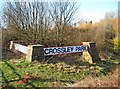
Crossley Retail Park sign
Crossley Park or Crossley Retail Park, as it is more usually known, is a typical edge of town retail park with many big multiple stores such as Comet, Currys, Halfords, P C World, Staples etc. etc. There is also a Sainsbury's supermarket and petrol filling station. This rather ugly sign near the entrance is easily overlooked and is beginning to be overgrown by vegetation.
Image: © P L Chadwick
Taken: 21 Mar 2010
0.06 miles