IMAGES TAKEN NEAR TO
Hemming Street, KIDDERMINSTER, DY11 6NB
Introduction
This page details the photographs taken nearby to Hemming Street, DY11 6NB by members of the Geograph project.
The Geograph project started in 2005 with the aim of publishing, organising and preserving representative images for every square kilometre of Great Britain, Ireland and the Isle of Man.

There are currently over 7.5m images from over14,400 individuals and you can help contribute to the project by visiting https://www.geograph.org.uk
Image Map
Images are licensed for reuse under creativecommons.org/licenses/by-sa/2.0
Notes
- Clicking on the map will re-center to the selected point.
- The higher the marker number, the further away the image location is from the centre of the postcode.
Image Listing (59 Images Found)
Images are licensed for reuse under creativecommons.org/licenses/by-sa/2.0
Image
Details
Distance
1
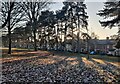
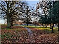
Trees in Brinton Park, Kidderminster
Brinton Park was opened on the 1st August 1887, in the year of Queen Victoria’s Golden Jubilee. John Brinton presented the 23-acre park for the benefit of the ‘townspeople’ of Kidderminster. John Brinton (1827–1914) was an English carpet manufacturer and a Liberal politician, he was born in Kidderminster.
The houses are along Sutton Road.
Image: © Mat Fascione
Taken: 16 Dec 2022
0.05 miles

4
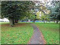
Footpath in Brinton Park, Sutton Road, Kidderminster, Worcs
In the distance is the children's play area. The footpath has come from the direction of Talbot Street and Franchise Street.
Image: © P L Chadwick
Taken: 5 Oct 2019
0.10 miles
5
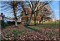
Northern edge of Brinton Park
The houses are on Talbot Street.
Image: © Mat Fascione
Taken: 15 Nov 2020
0.10 miles
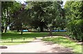
7
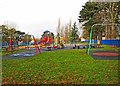
Children's Play Area, Brinton Park, Sutton Road, Kidderminster
The Children's Play Area is near the main Sutton Road entrance to this town centre public park.
Image: © P L Chadwick
Taken: 9 Dec 2012
0.12 miles
8
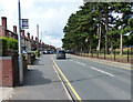
Sutton Road in Kidderminster
On the right is Brinton Park.
Image: © Mat Fascione
Taken: 28 Jul 2013
0.12 miles
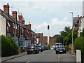
9
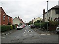
Franchise Street, Kidderminster, Worcs
A residential street seen from Talbot Street.
Image: © P L Chadwick
Taken: 5 Oct 2019
0.12 miles
10
Franchise Street, Kidderminster
Brinton Park is behind the photographer and Kidderminster Treatment Centre is seen in the distance with its chimney. This used to be Kidderminster General Hospital but was downgraded amidst a local political furore that saw a former consultant physician appointed as the local MP.
Image: © Chris Allen
Taken: 19 Jun 2017
0.12 miles